Queensland
Friday 6th July
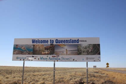
A short drive through the arid landscape brought us to the Queensland border. Here we put our watches forward half an hour as we are now in Eastern Standard Time, 10 hours ahead of Greenwich Mean Time.
In the small town of Camooweal, population 310, we stopped for fuel and food for tonight. For the latter there was little choice as the one small shop was really a post office that had diversified into selling a small range of everything.
Tonight we stopped just short of Mount Isa at a twenty four hour rest area called Gunpowder!
Saturday 7th July
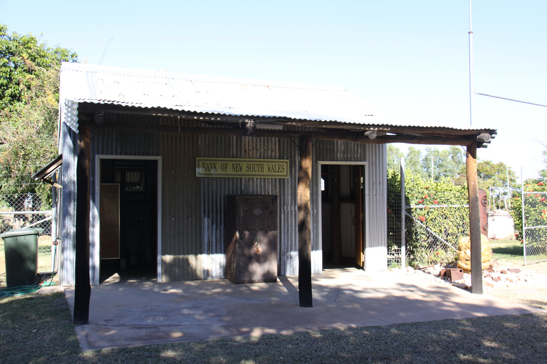
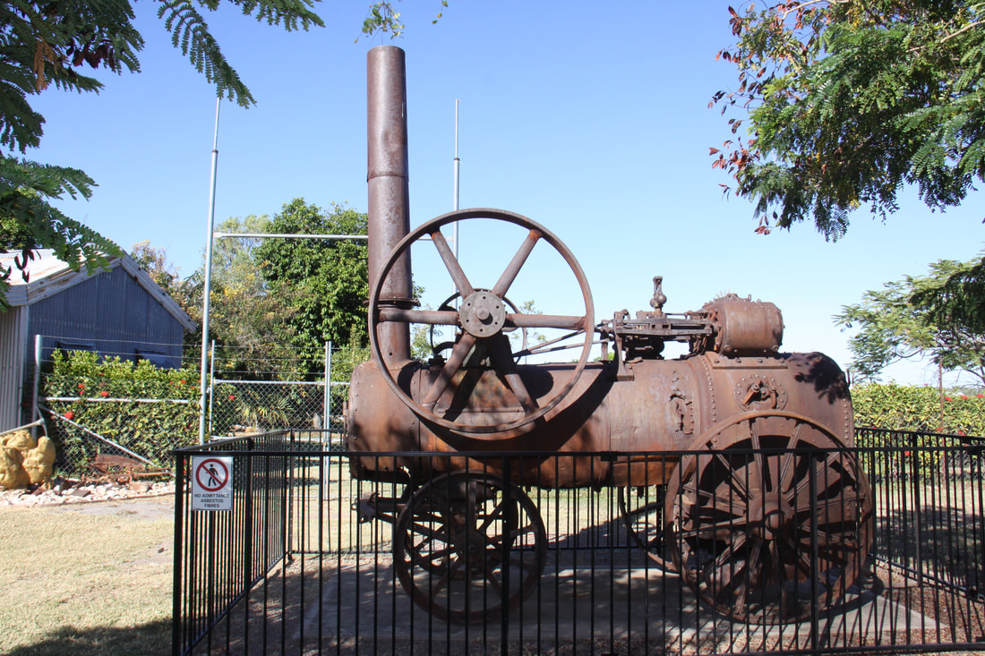
As we approached Mt Isa the scenery started to change from arid, flat semi-desert to bush covered low hills. But still the red soil that we have grown so used to seeing. Mt Isa is an industrial town and as we approached we saw that the mine was actually right in the centre of town. Zinc, silver, lead and copper have all been found in the area.
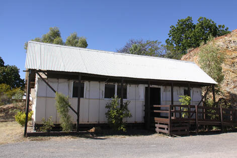
While in Mt Isa we visited the tent house, the last one still to stand. At least 180 of these houses were built as housing for miners and their families. They had tin roofs to protect the canvas sides and being quick to build they could quickly be relocated if necessary.
East of Mt Isa the landscape was quite dramatic - evidence of ancient upheavals that created the areas extensive mineral deposits. On reaching the outskirts of Cloncurry we left the Barkly Highway, the main east-west route in this part of Queensland and headed north along the Matilda Way for some fifty miles before stopping at a 24 hour rest area for the night.
As we approached Mt Isa the scenery started to change from arid, flat semi-desert to bush covered low hills. But still the red soil that we have grown so used to seeing. Mt Isa is an industrial town and as we approached we saw that the mine was actually right in the centre of town. Zinc, silver, lead and copper have all been found in the area.
While in Mt Isa we visited the tent house, the last one still to stand. At least 180 of these houses were built as housing for miners and their families. They had tin roofs to protect the canvas sides and being quick to build they could quickly be relocated if necessary.
East of Mt Isa the landscape was quite dramatic - evidence of ancient upheavals that created the areas extensive mineral deposits. On reaching the outskirts of Cloncurry we left the Barkly Highway, the main east-west route in this part of Queensland and headed north along the Matilda Way for some fifty miles before stopping at a 24 hour rest area for the night.
Sunday 8th July
We continued heading north this morning but it was slow progress as the road was in poor condition. At times it was a single track so you had to pull over onto the rough hard shoulder to pass. Road trains kept to the Tarmac so it was a case of move over or else.
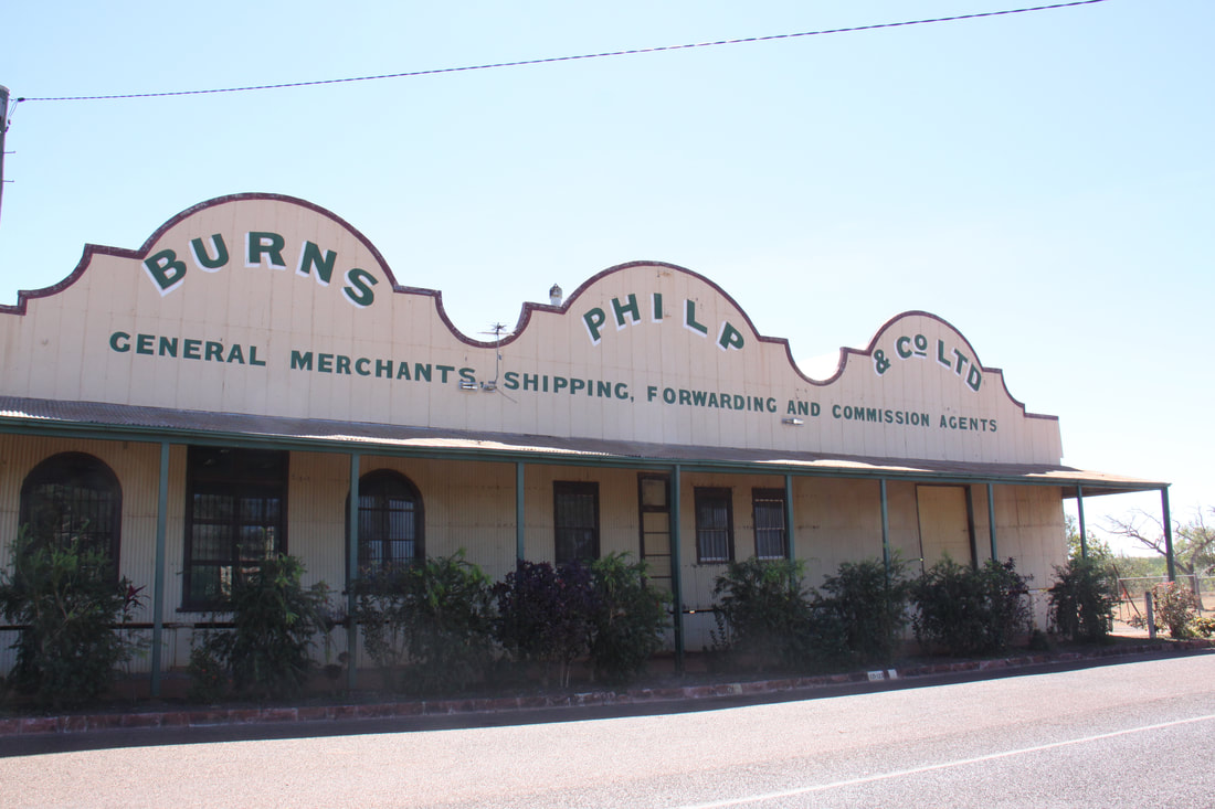
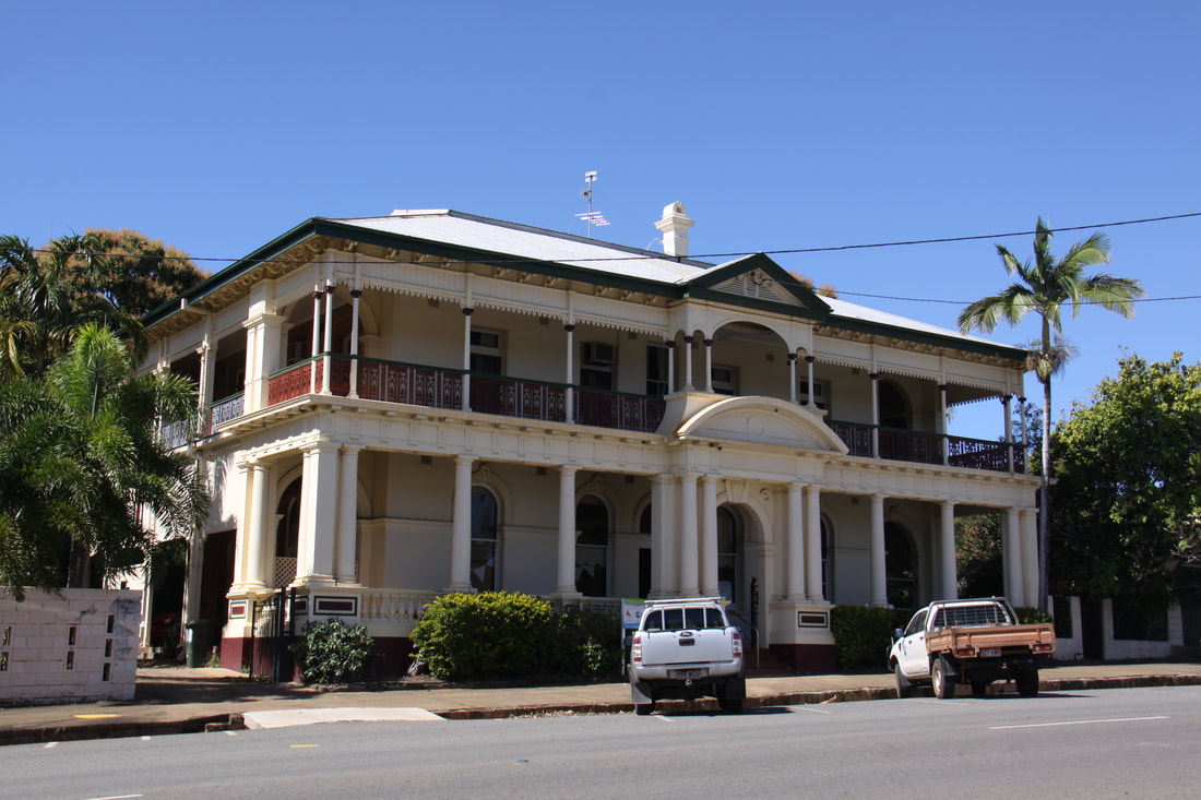
Eventually we reached the small town of Normanton. In the 1860s this was the main port of the area and was connected by rail to the goldfield at Croydon and Cloncurry's copper mines by camel train. A few historic buildings remain along the Main Street including the impressive timber built Burns Philp Store dating from the 1880s. It is enormous covering almost an acre.
After Normanton we turned east along the Savannah Way. As a road it was well surfaced and, by the amount of roadkill we passed, it is a fast road but there were no rest areas for a hundred miles. However we spotted a number of wallabies as well as iguana.
With no 24 hour rest area to use, we stopped for the night at a campsite in Croydon. This, now small town that has seen better days, was the site of Queensland 's last major gold rush in 1885
We continued heading north this morning but it was slow progress as the road was in poor condition. At times it was a single track so you had to pull over onto the rough hard shoulder to pass. Road trains kept to the Tarmac so it was a case of move over or else.
Eventually we reached the small town of Normanton. In the 1860s this was the main port of the area and was connected by rail to the goldfield at Croydon and Cloncurry's copper mines by camel train. A few historic buildings remain along the Main Street including the impressive timber built Burns Philp Store dating from the 1880s. It is enormous covering almost an acre.
After Normanton we turned east along the Savannah Way. As a road it was well surfaced and, by the amount of roadkill we passed, it is a fast road but there were no rest areas for a hundred miles. However we spotted a number of wallabies as well as iguana.
With no 24 hour rest area to use, we stopped for the night at a campsite in Croydon. This, now small town that has seen better days, was the site of Queensland 's last major gold rush in 1885
|
|
Monday 9th July
We spent this morning exploring the small town of Croydon where we had stayed last night. It has the feeling of a town frozen in time with most of its buildings dating from the 1920s or earlier.
An informative video at the Tourist Office set the scene. After the discovery of gold in the 1880s the town became the third largest in Queensland and was the service centre for the 18km long goldfield. The town is naturally proud of its history and its heritage centre with free access to five buildings is extremely informative. There was a lovely feel to the whole area.
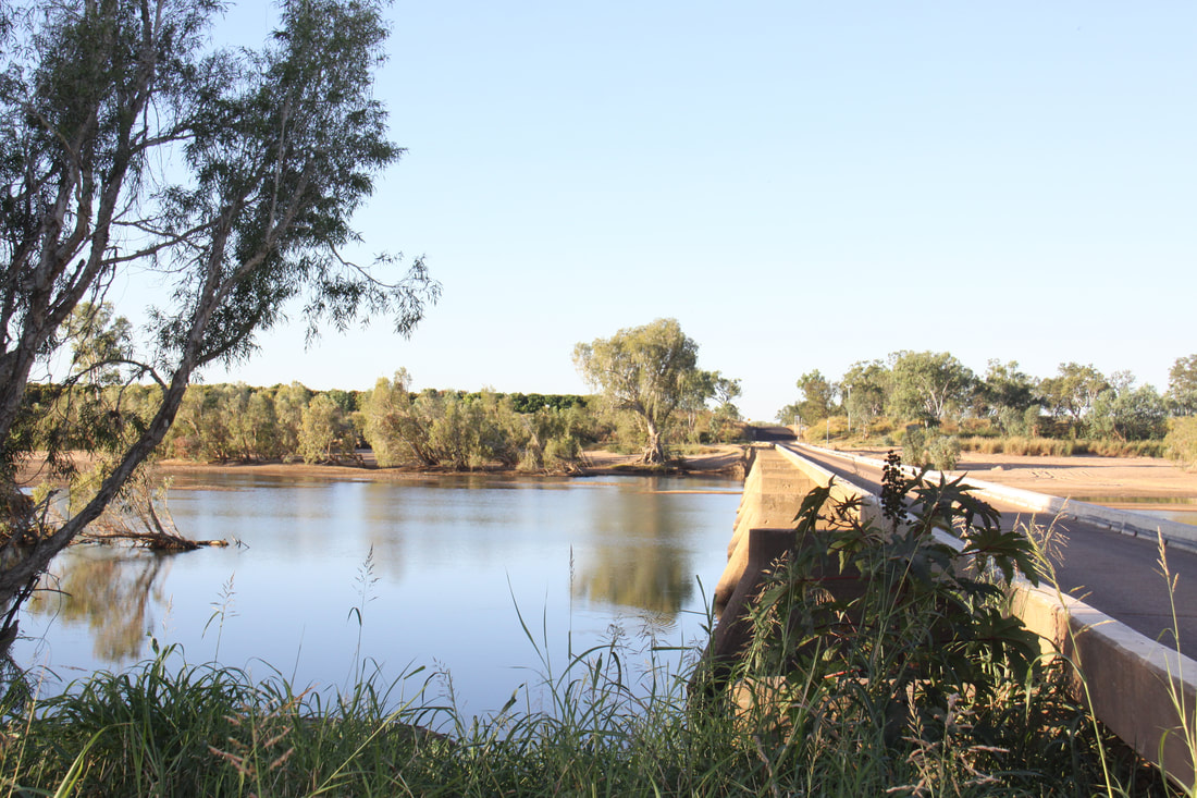
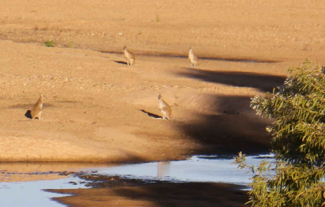
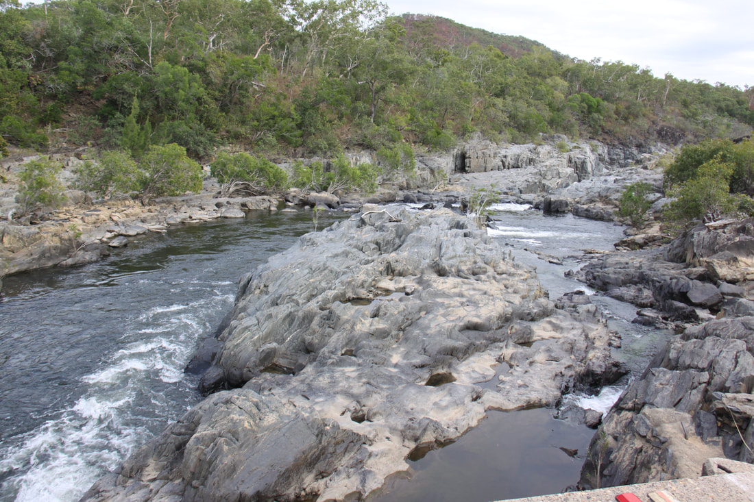
An hour's drive further east along the Savannah Way brought us to the Gilbert River, crossing of which is by a narrow single lane bridge. We stopped at the 24 hour test area here for the night. A number of wallabies were on the sand banks in the river.
We spent this morning exploring the small town of Croydon where we had stayed last night. It has the feeling of a town frozen in time with most of its buildings dating from the 1920s or earlier.
An informative video at the Tourist Office set the scene. After the discovery of gold in the 1880s the town became the third largest in Queensland and was the service centre for the 18km long goldfield. The town is naturally proud of its history and its heritage centre with free access to five buildings is extremely informative. There was a lovely feel to the whole area.
An hour's drive further east along the Savannah Way brought us to the Gilbert River, crossing of which is by a narrow single lane bridge. We stopped at the 24 hour test area here for the night. A number of wallabies were on the sand banks in the river.
|
|
|
|
|
|
Tuesday 10th July
Our journey east along the Savannah Way was slow today as at least 100km was a single track meaning that whenever we met an approaching vehicle we had to drive with one side of Nicolle on the Tarmac and the other on the gravel hard shoulder. Approaching vehicles threw up large dust clouds.
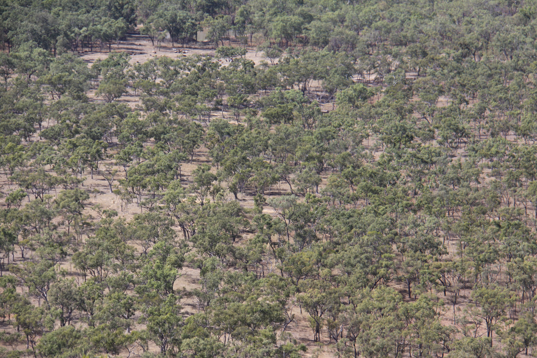
The Savannah grasslands have had a beauty of their own and were certainly greener than the red centre. The further east we drove so the vegetation changed. Settlements were still small and spaced far part from each other, but the true isolation is gradually giving way to a civilisation of sorts.
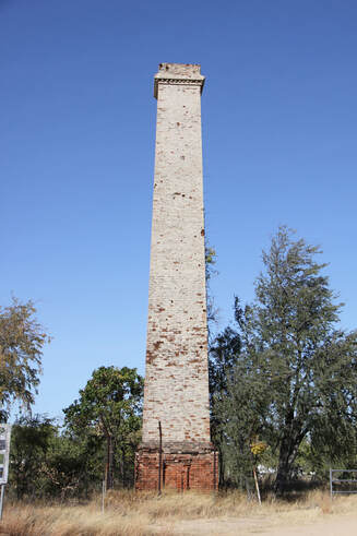
We made a brief stop at the Cumberland Tower, a tall mill chimney, all that is left of the former mining town of Cumberland. Then, apart from a stop at Georgetown for the tourist office, food and fuel (gradually getting cheaper) and a lunch stop at Mount Surprise, the rest of the day was spent driving.
Our journey east along the Savannah Way was slow today as at least 100km was a single track meaning that whenever we met an approaching vehicle we had to drive with one side of Nicolle on the Tarmac and the other on the gravel hard shoulder. Approaching vehicles threw up large dust clouds.
The Savannah grasslands have had a beauty of their own and were certainly greener than the red centre. The further east we drove so the vegetation changed. Settlements were still small and spaced far part from each other, but the true isolation is gradually giving way to a civilisation of sorts.
We made a brief stop at the Cumberland Tower, a tall mill chimney, all that is left of the former mining town of Cumberland. Then, apart from a stop at Georgetown for the tourist office, food and fuel (gradually getting cheaper) and a lunch stop at Mount Surprise, the rest of the day was spent driving.
Wednesday 11th July
A short drive this morning across the heart of the Atherton Tablelands brought a complete change of scene. High arable pastures intersected by deep valleys with an early morning mist adding to the atmosphere of the area.
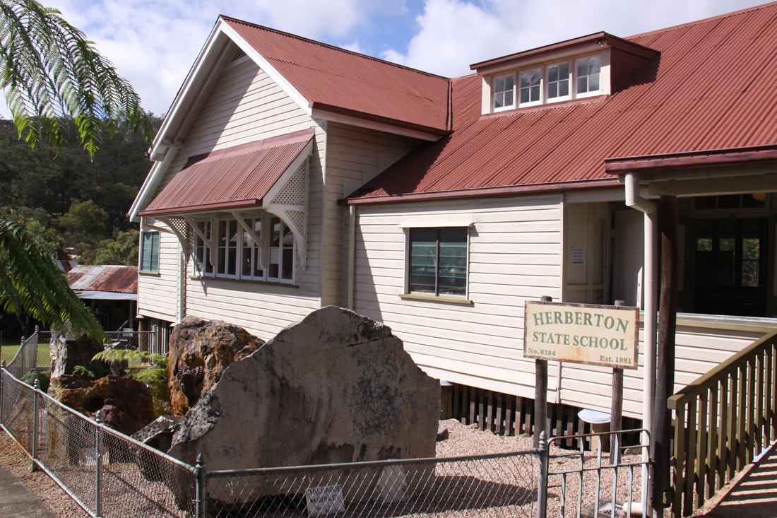
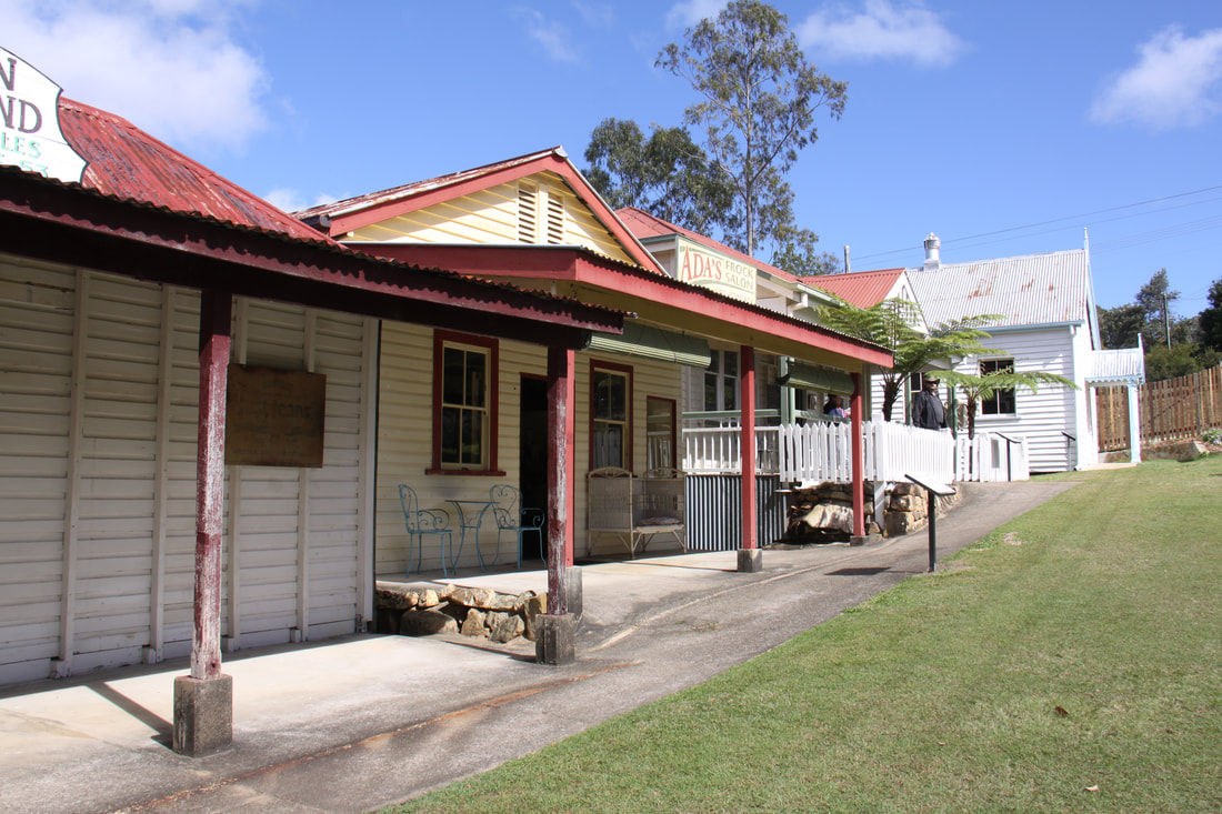
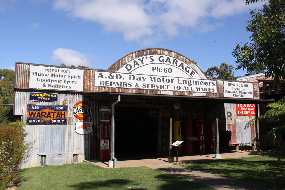
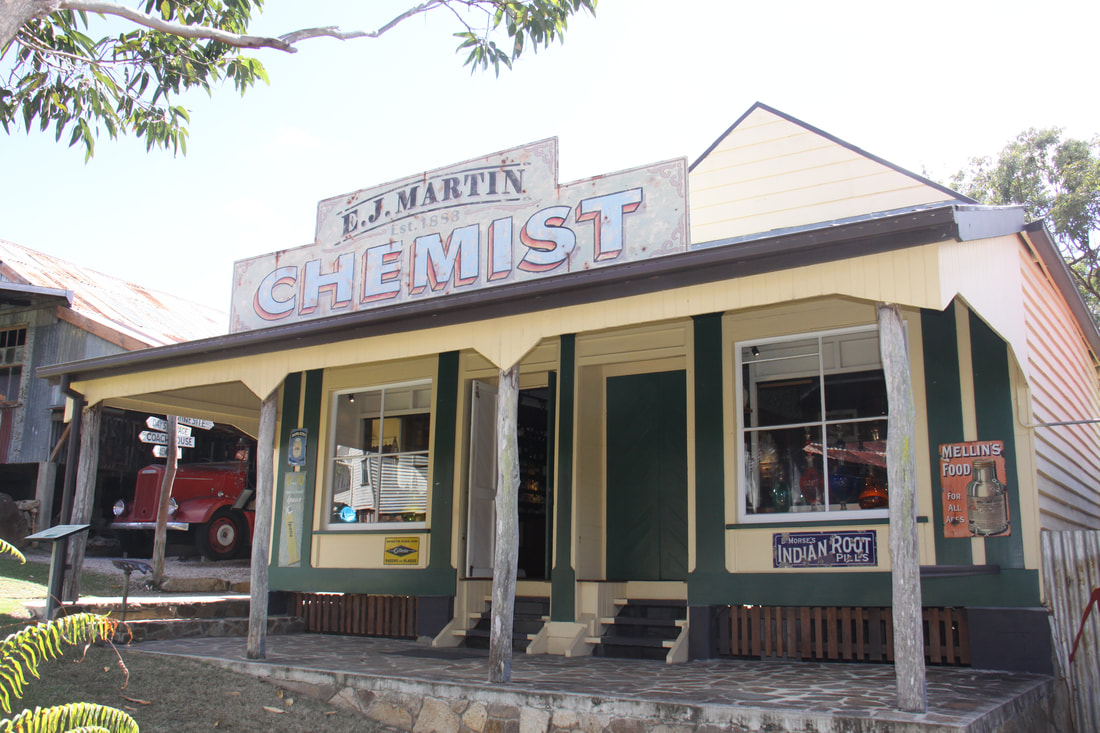
We spent most of the day at the Historic Village of Herberton. The village has been set out as a typical tin mining town. Its streets take you back in time to the 1800s with their well preserved buildings. A vast range of collections provide a glimpse of what life would have been like. At its heart is the Elderslic House whose owners were the inspiration for this superb museum. Live demonstrations and working machinery give this open air museum a real sense of how the early settlers lived and worked. A wonderful experience.
Overnight stopovers are now less frequent so we stopped not far on from Herberton for the night. The next such area is 250km away!
A short drive this morning across the heart of the Atherton Tablelands brought a complete change of scene. High arable pastures intersected by deep valleys with an early morning mist adding to the atmosphere of the area.
We spent most of the day at the Historic Village of Herberton. The village has been set out as a typical tin mining town. Its streets take you back in time to the 1800s with their well preserved buildings. A vast range of collections provide a glimpse of what life would have been like. At its heart is the Elderslic House whose owners were the inspiration for this superb museum. Live demonstrations and working machinery give this open air museum a real sense of how the early settlers lived and worked. A wonderful experience.
Overnight stopovers are now less frequent so we stopped not far on from Herberton for the night. The next such area is 250km away!
|
|
|
|
Thursday 12th July
Today we headed north to Cooktown, the end of the paved road. It was a drive through widely contrasting regions - flat Savannah grasslands, rocky and often steep passes through the Kuranda range and lush tropical rainforest. The one missing, or rather limited, item was a lack of pull-ins where you could take a break. We passed a number of tiny settlements, mainly former mining towns which now have only a solitary motel, garage and sometimes a campsite.
We had planned on staying tonight at a rest area just short of Cooktown but it was down a steep, stony track just by a dangerous bend and a rough river crossing, so we decided to carry on to the RV rest area by Cooktown Racetrack.
Friday 13th July
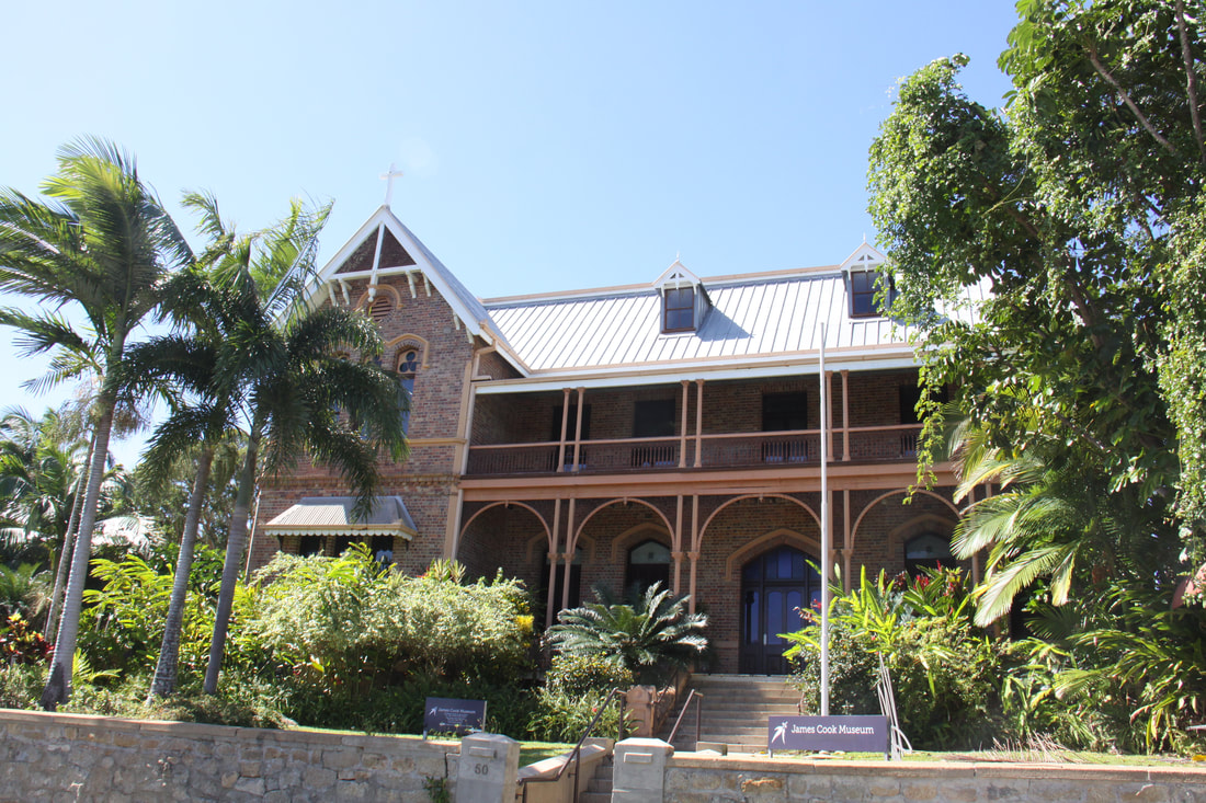
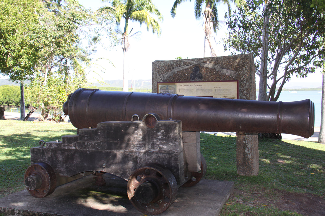
Today we spent exploring the delightful small town of Cooktown which owes its existence to the discovery of gold in the 1870's. However, it is more famous as the site of Captain James Cook's refuge following the floundering of his ship the "Endeavour" on the Great Barrier Reef, one hundred years earlier. He and his men spent two months here while his ship was being repaired. The James Cook Museum has one of the six cannons rescued from the reef where they were jettisoned in an attempt to lighten the "Endeavour" when it struck.
We spent a while in the museum which features extracts from the ship's log together with accounts of Cook's time in this part of Australia. He and his crew befriended the local population and discovered kangaroos for the first time. Cook asked a native what the animal was called, the answer being "Gangarou" which, apparently means "I don't know!" The answer stuck.
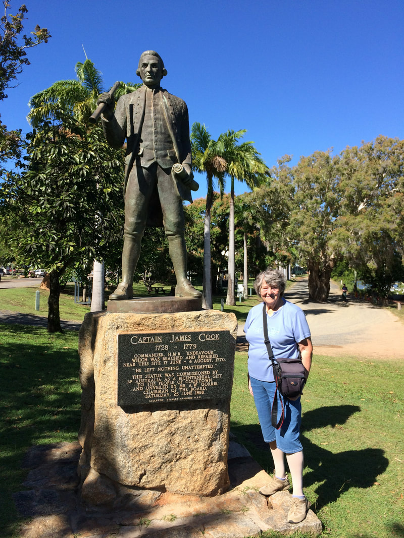
The rest of the day was sent following the town trail, past old buildings in the town centre down to the coast and wharf, where there is a statue of Cook and the actual point marked where he stepped ashore. Further along the wharf are the Queen's Steps where Queen Elizabeth II stepped ashore when she took part in Australia's Bicentennial Celebrations.
Today we headed north to Cooktown, the end of the paved road. It was a drive through widely contrasting regions - flat Savannah grasslands, rocky and often steep passes through the Kuranda range and lush tropical rainforest. The one missing, or rather limited, item was a lack of pull-ins where you could take a break. We passed a number of tiny settlements, mainly former mining towns which now have only a solitary motel, garage and sometimes a campsite.
We had planned on staying tonight at a rest area just short of Cooktown but it was down a steep, stony track just by a dangerous bend and a rough river crossing, so we decided to carry on to the RV rest area by Cooktown Racetrack.
Friday 13th July
Today we spent exploring the delightful small town of Cooktown which owes its existence to the discovery of gold in the 1870's. However, it is more famous as the site of Captain James Cook's refuge following the floundering of his ship the "Endeavour" on the Great Barrier Reef, one hundred years earlier. He and his men spent two months here while his ship was being repaired. The James Cook Museum has one of the six cannons rescued from the reef where they were jettisoned in an attempt to lighten the "Endeavour" when it struck.
We spent a while in the museum which features extracts from the ship's log together with accounts of Cook's time in this part of Australia. He and his crew befriended the local population and discovered kangaroos for the first time. Cook asked a native what the animal was called, the answer being "Gangarou" which, apparently means "I don't know!" The answer stuck.
The rest of the day was sent following the town trail, past old buildings in the town centre down to the coast and wharf, where there is a statue of Cook and the actual point marked where he stepped ashore. Further along the wharf are the Queen's Steps where Queen Elizabeth II stepped ashore when she took part in Australia's Bicentennial Celebrations.
|
|
|
|
|
Saturday 14th July
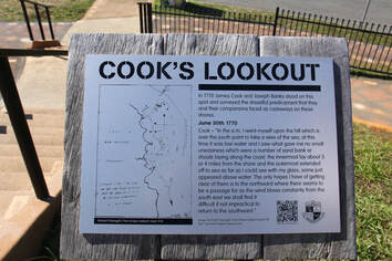
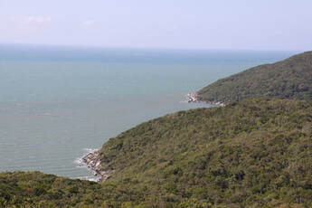
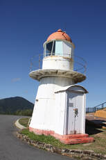
Today there was a very diverse market in Lion's Park, Cooktown - food stalls, local crafts, fruit and vegetables, adorable puppies plus a hairdresser. As we were both in need of a haircut we quickly joined the queue for a trim. Once we had explored what the market had to offer we drove up the very steep hill known locally as Grassy Hill. From the lookout at the top there were panoramic views across Cooktown, the Endeavour River and Coral Sea. It was from this point that James Cook studied the Coral Sea and its reefs to locate a safe passage out of the river after repairing his ship. The lighthouse on top of the hill was built in Birmingham and shipped to Cooktown in 1885.
At the foot of Grassy Hill are the Cooktown Botanic Gardens. They were established in 1878 and as such are one of Australia's oldest. In the gardens are living specimens of the 325 plants collected by Sir Joseph Banks and Daniel Solander, both of whom were on board the Endeavour when it ran aground in 1770.
As we were at the seaside we had to have fish and chips, freshly caught Spanish Mackerel from a shop by the harbour, before heading back to our final night at the RV Rest Area in Cooktown.
|
|
|
|
|
|
Sunday 15th July
We were sad to leave Cooktown this morning but our 72 hours allowed at the RV rest area was up and the campsite was booked solid.
All roads leading north further into the Cape York Peninsula are 4WD only so we had to retrace our steps south. We stopped at a number of lookouts en route.
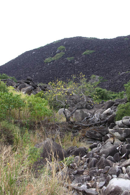
The Black Mountain looked over a jumble of huge boulders, a remnant of molten lava which cooled below the earth's surface 240 million years ago. Over the millennia the softer rocks and soil were washed away exposing a granite block. Water seeped into gaps breaking the slab into smaller blocks which were rounded by subsequent erosion.
The pretty Little Annan River with its water bubbling over rocks and small waterfalls was crossed by a rough road which floods during the rainy season. Luckily we were here in the dry season! Our final stop was at Bob's Lookout with its far ranging view across a wide sandy valley of Savannah grasslands dotted with trees.
Tonight was spent at the very busy Rifle Creek overnight rest area.
We were sad to leave Cooktown this morning but our 72 hours allowed at the RV rest area was up and the campsite was booked solid.
All roads leading north further into the Cape York Peninsula are 4WD only so we had to retrace our steps south. We stopped at a number of lookouts en route.
The Black Mountain looked over a jumble of huge boulders, a remnant of molten lava which cooled below the earth's surface 240 million years ago. Over the millennia the softer rocks and soil were washed away exposing a granite block. Water seeped into gaps breaking the slab into smaller blocks which were rounded by subsequent erosion.
The pretty Little Annan River with its water bubbling over rocks and small waterfalls was crossed by a rough road which floods during the rainy season. Luckily we were here in the dry season! Our final stop was at Bob's Lookout with its far ranging view across a wide sandy valley of Savannah grasslands dotted with trees.
Tonight was spent at the very busy Rifle Creek overnight rest area.
|
|
Monday 16th July
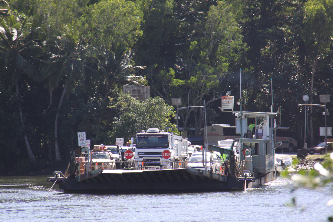
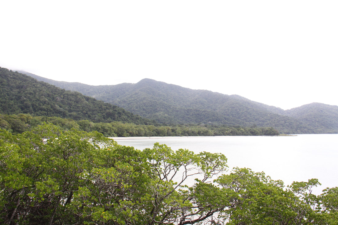
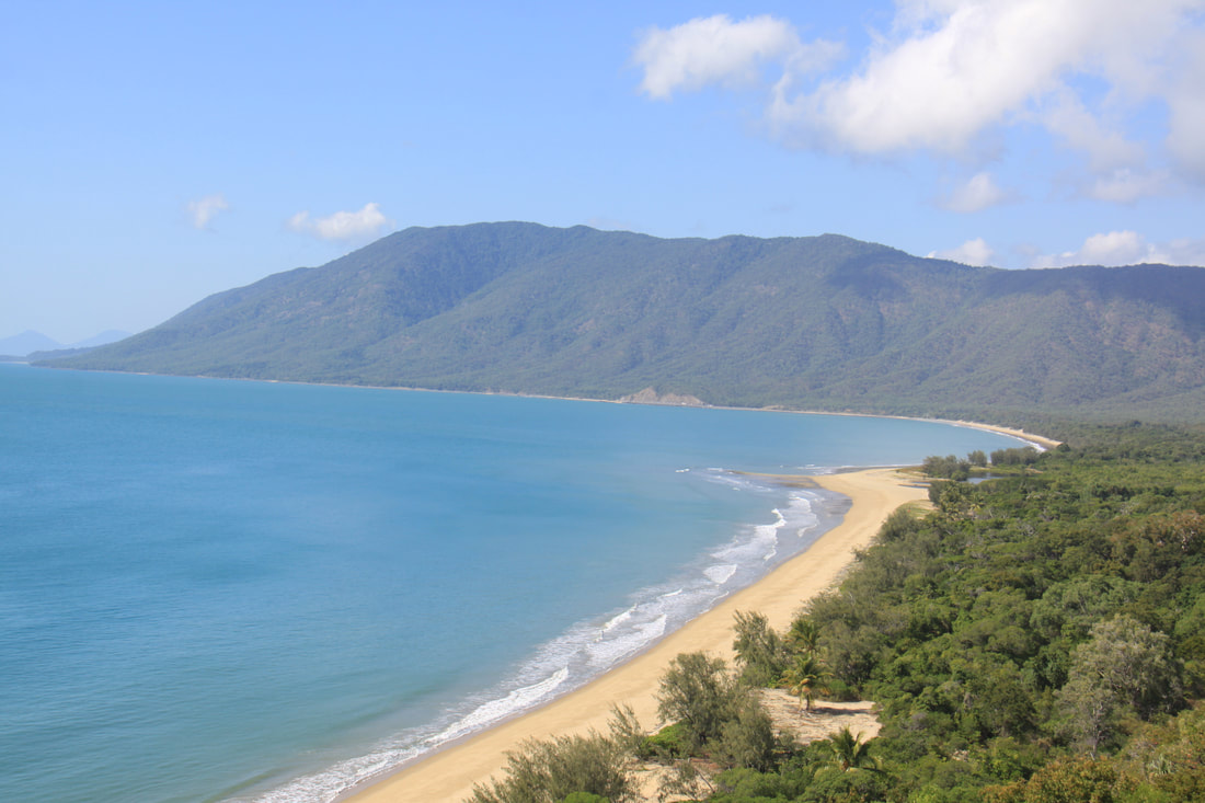
We made a prompt start this morning as we wanted to get to the busy Daintree River Crossing ferry as early as possible as it gets very busy. The road across to Mossman went through beautiful woodland, banana plantations, fields of sugar cane and tea plantations. As we dropped down off the Atherton Plateau the road was twisty and narrow affording expansive views across to the coast and Daintree Rainforest, the oldest tropical rainforest in the world and a UNESCO World Heritage Site.
We stopped for food, fuel and a bank at Mossman, (still no wifi, the whole area has been without an internet signal for the last three days!), before heading for the 5 minute ferry crossing over the Daintree River. There is only one road up to the end of the tar at Cape Tribulation. It is a twisty, often narrow road through spectacular tropical rain forest. Although the school holidays in Queensland have now ended, everywhere was still very busy and at times parking was not easy.
After stopping at a coastal lookout we headed straight to Cape Tribulation. It was off this cape that James Cook's ship "Endeavour " struck part of the Great Barrier Reef. He gave the cape its name as it was here he stated, that his troubles had begun. We followed a broadwalk to a lookout point.
As everywhere was so busy, we started looking for a campsite after lunch. We struck lucky at the third attempt. There are no overnight rest areas in the National Park.
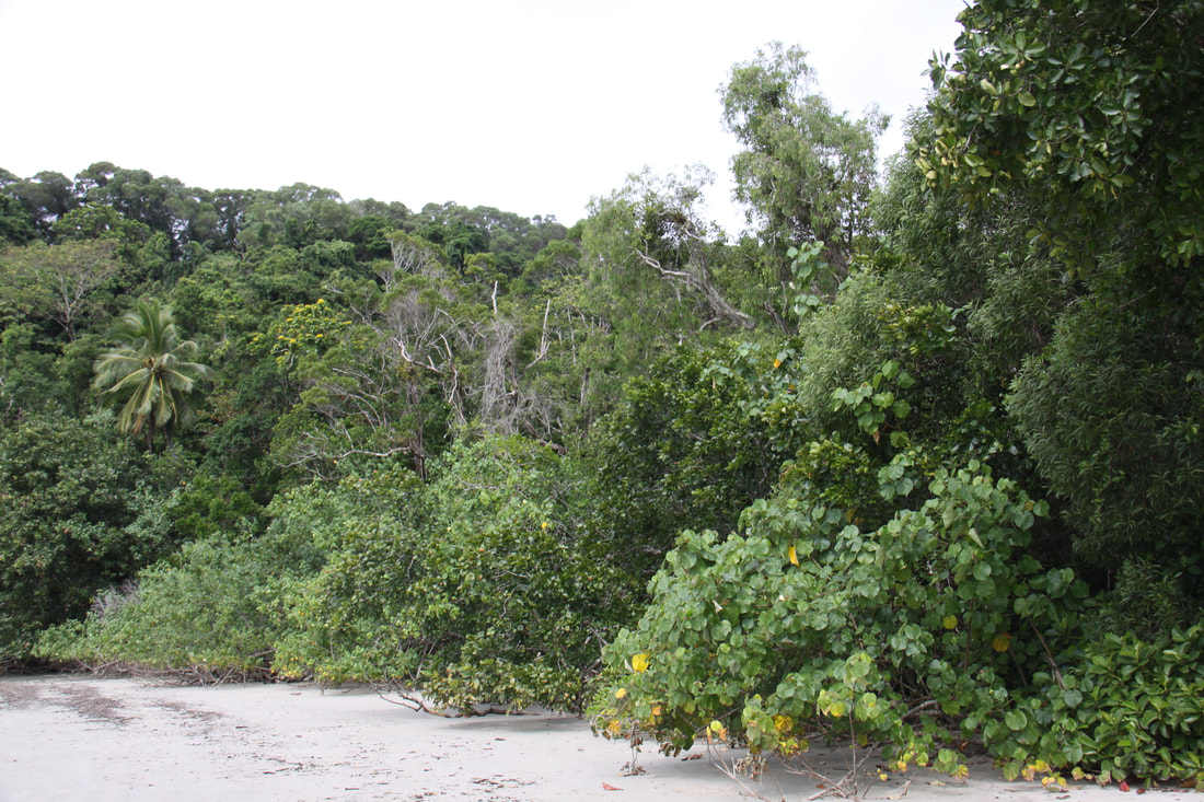
From the campsite it was only a short walk to the Dubiji broadwalk which took us through both rainforest and coastal mangrove (John said that was no longer politically correct and they were now called "person groves") to the beach. We walked along the beach towards Tribulation Bay and took another broadwalk through the mangrove swamp and returned to our campsite.
We over-nighted at Ocean Safari Lodge, a small and busy campsite.
We made a prompt start this morning as we wanted to get to the busy Daintree River Crossing ferry as early as possible as it gets very busy. The road across to Mossman went through beautiful woodland, banana plantations, fields of sugar cane and tea plantations. As we dropped down off the Atherton Plateau the road was twisty and narrow affording expansive views across to the coast and Daintree Rainforest, the oldest tropical rainforest in the world and a UNESCO World Heritage Site.
We stopped for food, fuel and a bank at Mossman, (still no wifi, the whole area has been without an internet signal for the last three days!), before heading for the 5 minute ferry crossing over the Daintree River. There is only one road up to the end of the tar at Cape Tribulation. It is a twisty, often narrow road through spectacular tropical rain forest. Although the school holidays in Queensland have now ended, everywhere was still very busy and at times parking was not easy.
After stopping at a coastal lookout we headed straight to Cape Tribulation. It was off this cape that James Cook's ship "Endeavour " struck part of the Great Barrier Reef. He gave the cape its name as it was here he stated, that his troubles had begun. We followed a broadwalk to a lookout point.
As everywhere was so busy, we started looking for a campsite after lunch. We struck lucky at the third attempt. There are no overnight rest areas in the National Park.
From the campsite it was only a short walk to the Dubiji broadwalk which took us through both rainforest and coastal mangrove (John said that was no longer politically correct and they were now called "person groves") to the beach. We walked along the beach towards Tribulation Bay and took another broadwalk through the mangrove swamp and returned to our campsite.
We over-nighted at Ocean Safari Lodge, a small and busy campsite.
|
|
|
|
Tuesday 17th July
It rained a little overnight - well we are in a rainforest! Only the second time we've had rain in two months.
We retraced our steps back to the ferry across the Daintree River. The road is very narrow and winding, with sheer drops on one side and little protection if you had to swerve suddenly. When you met a lot of traffic coming the other way you knew that a ferry was in!
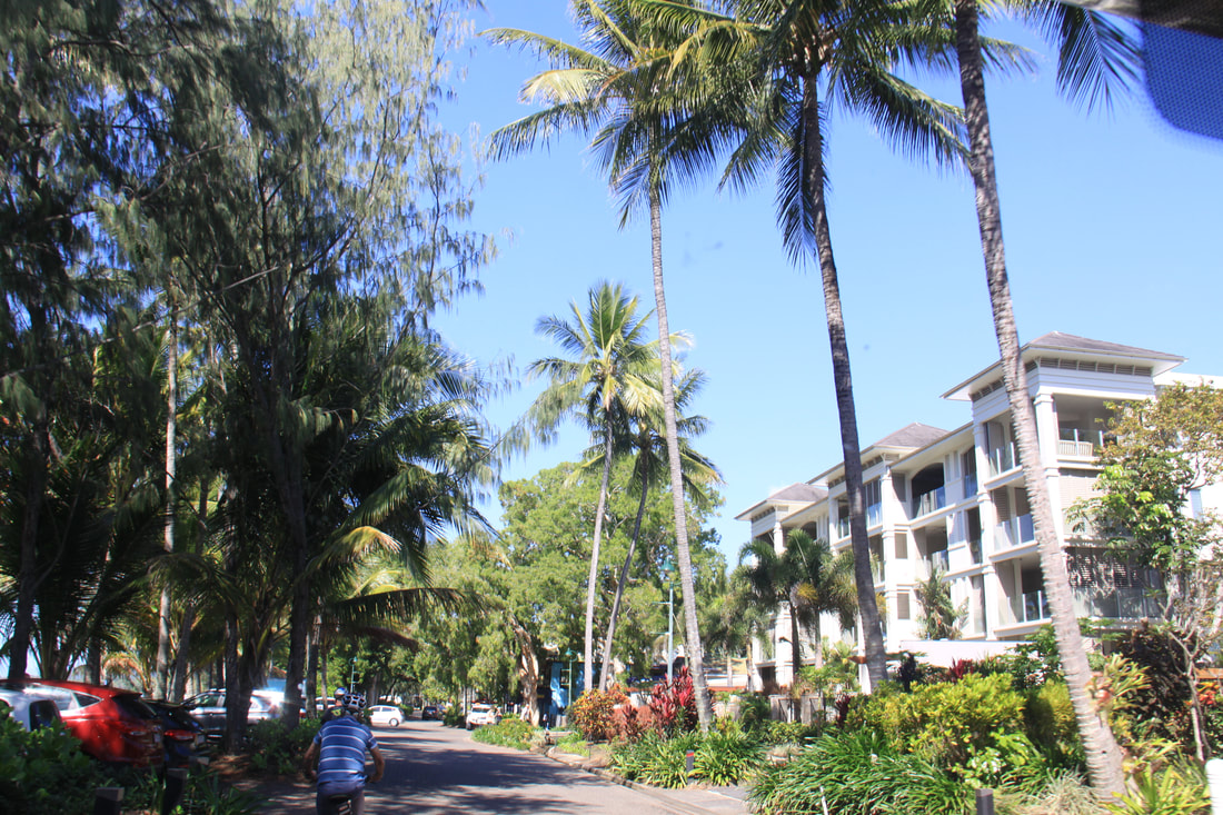
It was only a short drive back through Mossman and on to Port Douglas, our destination. We were fortunate to find a space on a campsite as it is very much peak holiday season in this area. Once ensured of our night's pitch we went to the Tourist Office where we booked our trip to the Great Barrier Reef. Something to look forwards to tomorrow.
It has been dull and overcast all day but still warm and very humid. After dark the rain came. Still no internet.
Wednesday 18th July
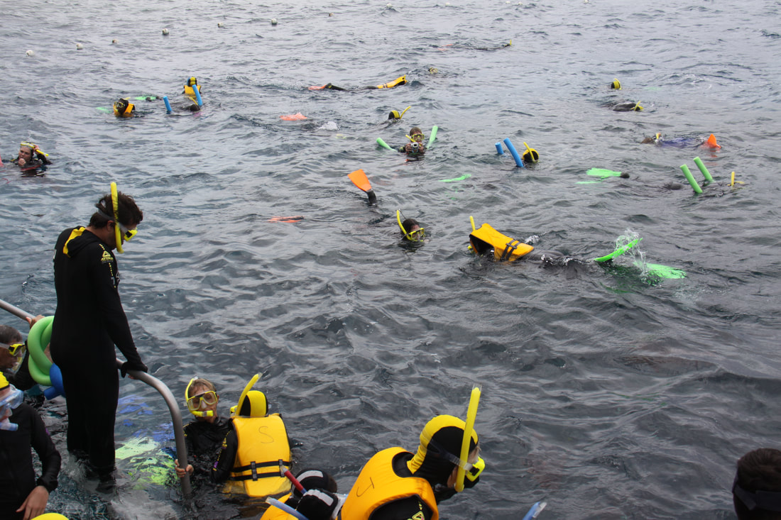
Wow, what a wonderful day. We had booked a full day tour out to the Great Barrier Reef and it did not disappoint.
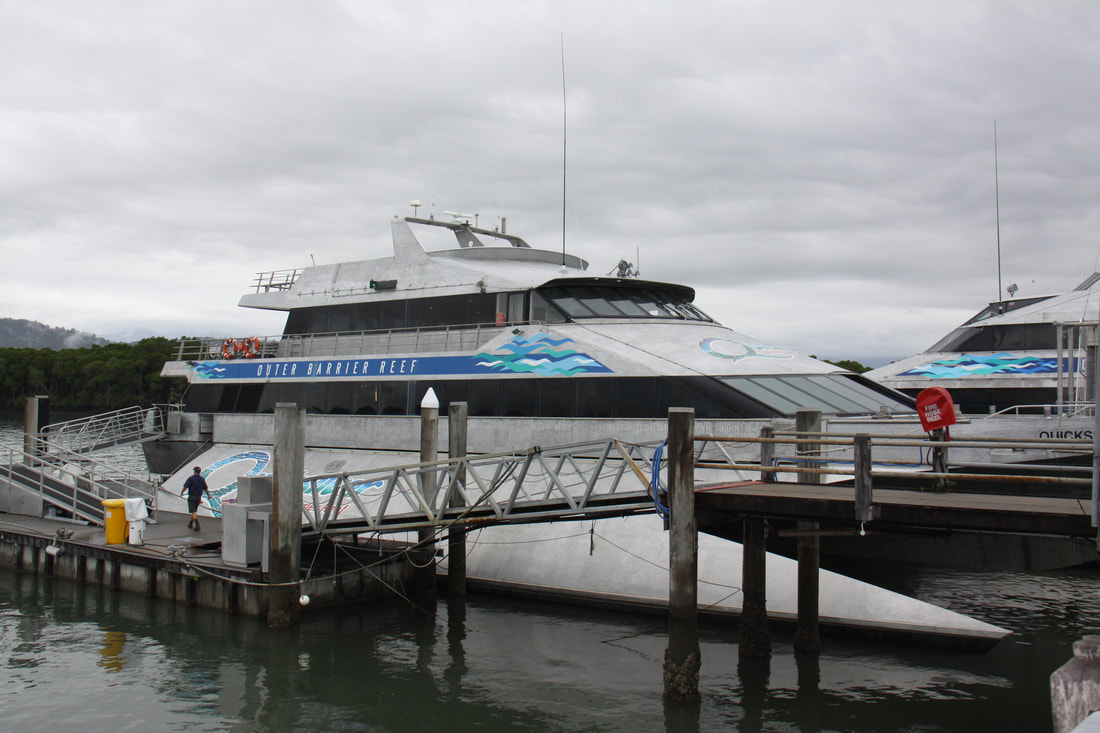
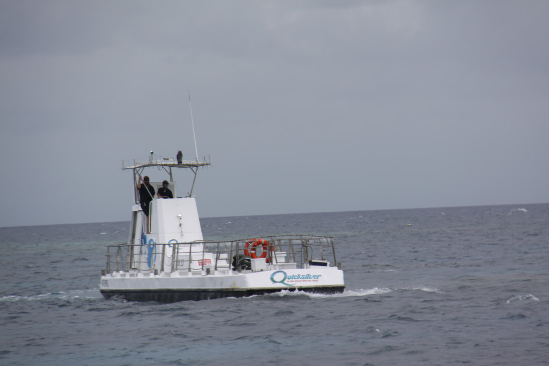
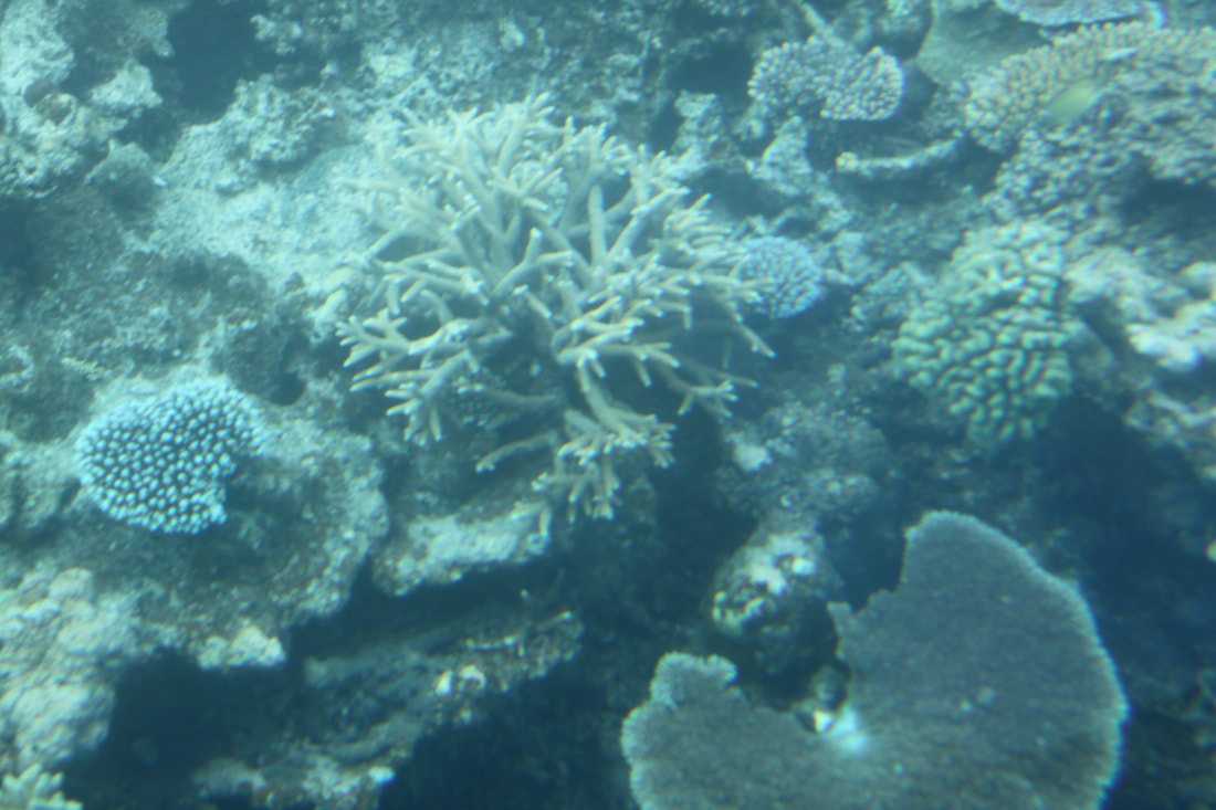
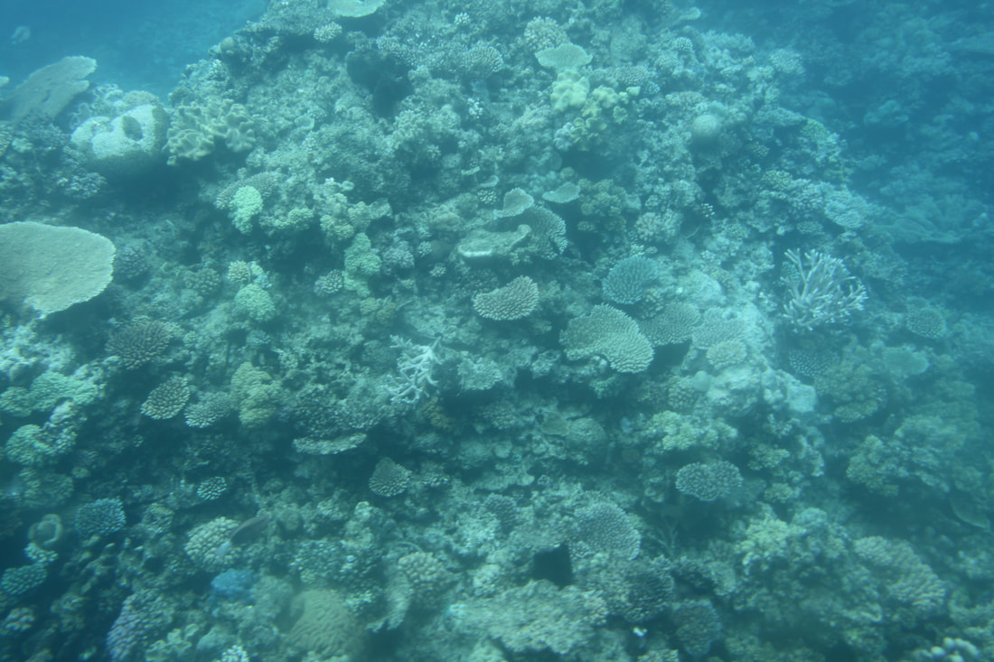
We left Port Douglas on a powerful high speed catamaran capable of 25 knots. Despite inclement weather it was a very comfy trip. During the outer journey a marine biologist gave a very interesting, illustrated talk on what we could expect to see once we reached the reef. Agincourt Reef sits right on the edge of the Continental Shelf and is one of the "ribbons" of reef that run parallel to the edge of the shelf. It is a pristine eco-system where clear waters give the best possible underwater visibility. The entire Great Barrier Reef is UNESCO listed.
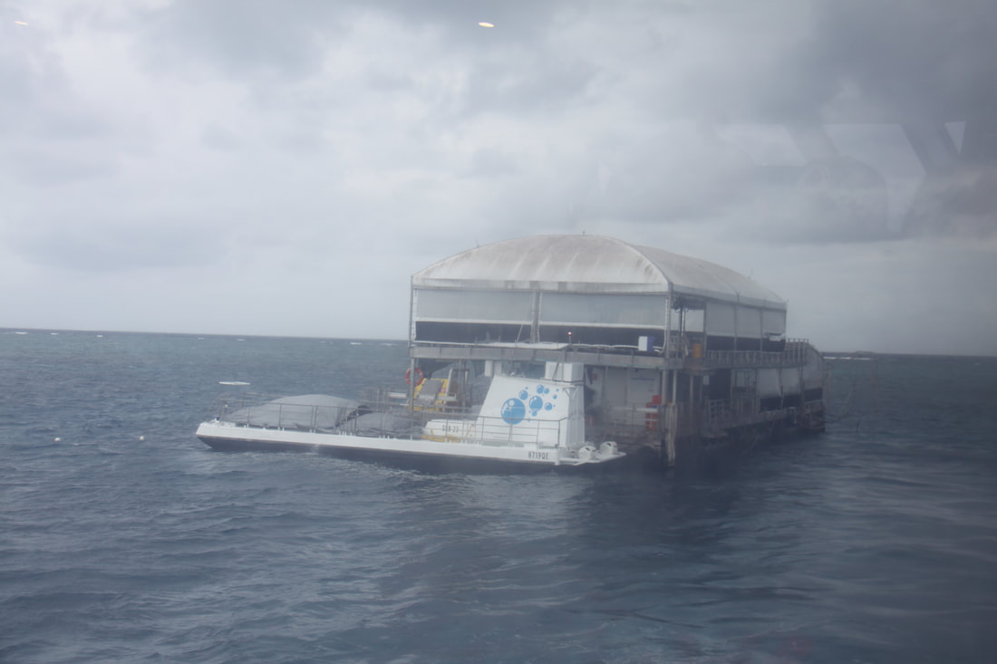
The catamaran moored alongside a pontoon from which there were a choice of activities. John and I managed to fit in three trips in the semi-submersible reef viewer and on each trip we saw different types of coral, turtles, fish of all hues and size plus sharks.
Our time on the pontoon passed all too quickly and after three hours out on the reef, we had to head back to shore. It was one amazing day and given the chance (and the money), we would do it all again tomorrow.
It rained a little overnight - well we are in a rainforest! Only the second time we've had rain in two months.
We retraced our steps back to the ferry across the Daintree River. The road is very narrow and winding, with sheer drops on one side and little protection if you had to swerve suddenly. When you met a lot of traffic coming the other way you knew that a ferry was in!
It was only a short drive back through Mossman and on to Port Douglas, our destination. We were fortunate to find a space on a campsite as it is very much peak holiday season in this area. Once ensured of our night's pitch we went to the Tourist Office where we booked our trip to the Great Barrier Reef. Something to look forwards to tomorrow.
It has been dull and overcast all day but still warm and very humid. After dark the rain came. Still no internet.
Wednesday 18th July
Wow, what a wonderful day. We had booked a full day tour out to the Great Barrier Reef and it did not disappoint.
We left Port Douglas on a powerful high speed catamaran capable of 25 knots. Despite inclement weather it was a very comfy trip. During the outer journey a marine biologist gave a very interesting, illustrated talk on what we could expect to see once we reached the reef. Agincourt Reef sits right on the edge of the Continental Shelf and is one of the "ribbons" of reef that run parallel to the edge of the shelf. It is a pristine eco-system where clear waters give the best possible underwater visibility. The entire Great Barrier Reef is UNESCO listed.
The catamaran moored alongside a pontoon from which there were a choice of activities. John and I managed to fit in three trips in the semi-submersible reef viewer and on each trip we saw different types of coral, turtles, fish of all hues and size plus sharks.
Our time on the pontoon passed all too quickly and after three hours out on the reef, we had to head back to shore. It was one amazing day and given the chance (and the money), we would do it all again tomorrow.
|
|
|
|
Thursday 19th July
Our third day at Pandanus Tourist Park. It was dry overnight and today is a little brighter with a light breeze.
Spent the morning doing the laundry. After lunch set out to find a car wash. It's been two months and 8000 miles of very dusty sandy roads since Nicolle was cleaned! We also needed to do some food shopping and hopefully we might find somewhere where there is internet.
The lady running the campsite has managed to book us onto the Kuranda Skyrail and Scenic Train Tour tomorrow (the man at the tourist office had told us it was full) so we've booked another day on the campsite.
Friday 20th July
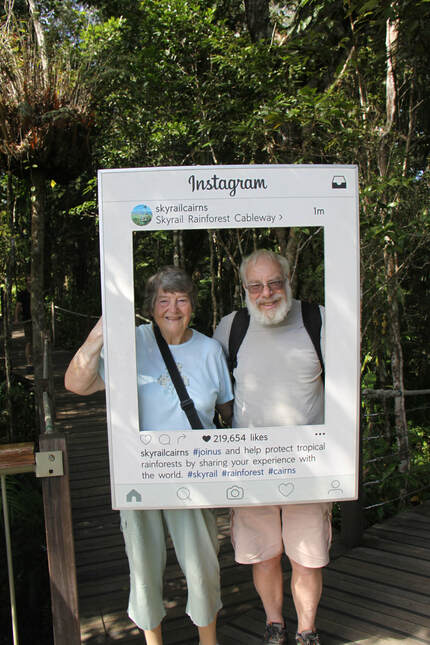
Today we joined a small tour group for a trip to the Kuranda Scenic Railway followed by the Skyrail Rainforest Cableway.
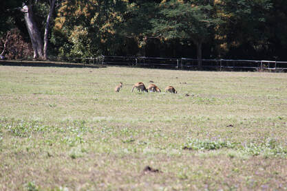
We were picked up from the campsite by our friendly and efficient guide/ driver, Hilary at 8.30am. The journey south towards Cairns was a destination in itself. The Captain Cook highway hugs the coast between Port Douglas and Cairns. Sparkling blue sea edged by pristine sandy beaches on one side and thick tropical forests on the other. Dotted along the shoreline were a number of picturesque villages including Palm Cove, an upmarket seaside village where we were to stop for cocktails later in the day. We spotted a crocodile on a muddy river bank and on the outskirts of the suburbs of Cairns there was a field, quite literally covered with wallabies.
Our destination for the day was the small inland village of Kuranda which lies in the middle of the World Heritage Rainforest, 1000ft above Cairns. The village, which has a quirky mix of shops and markets, gained fame in the 1960s when hippies discovered its charm and moved in.
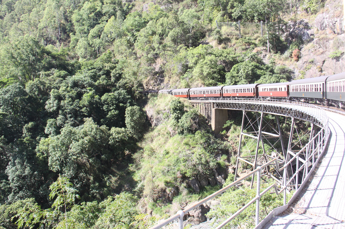
As well as driving to Kuranda you can also visit it by using the Kuranda Scenic Railway or the Skyrail. Our trip included an ascent on the railway and return in the gondola.
The Kuranda Scenic Railway track was originally built in the late 1880s so that the ores from the rich mining belt, including gold, which had developed on the Atherton Highlands could be more easily transported down to the coast. Today, trains leave Cairns for the hour and a half journey along the picturesque track carrying tourists rather than precious metals. There is an onboard commentary describing each section of the track and explaining the difficulties encountered in constructing the railway on the precipitous slopes through the tropical rainforest.
The station at Kuranda was built in 1915 and many of the railway carriages date from the 1930s. Kuranda itself is really just two streets and two market areas. We wandered around the latter then had a "German" lunch, John was very pleased that they served real German beer!
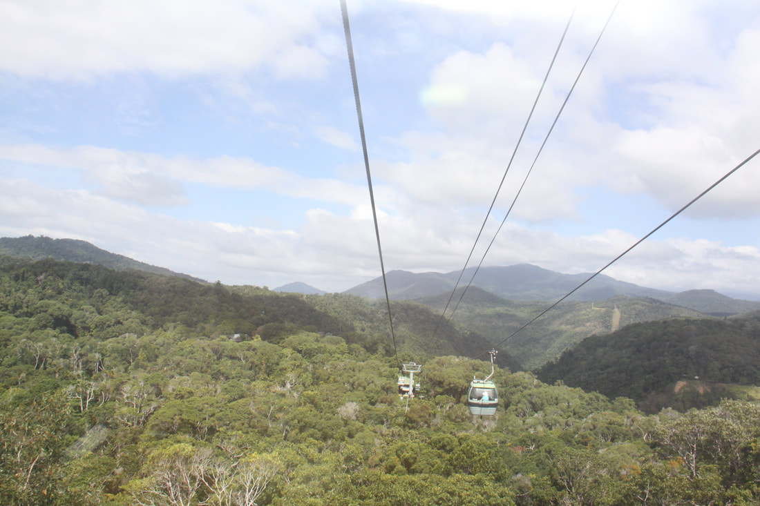
After lunch we headed for the Skyrail Rainforest Cableway. As we glided high above the rainforest canopy, we had far reaching views across to Cairns. At Red Peak Station we had to change to a different cable car so before we did this we followed the short broad walk through the rainforest.
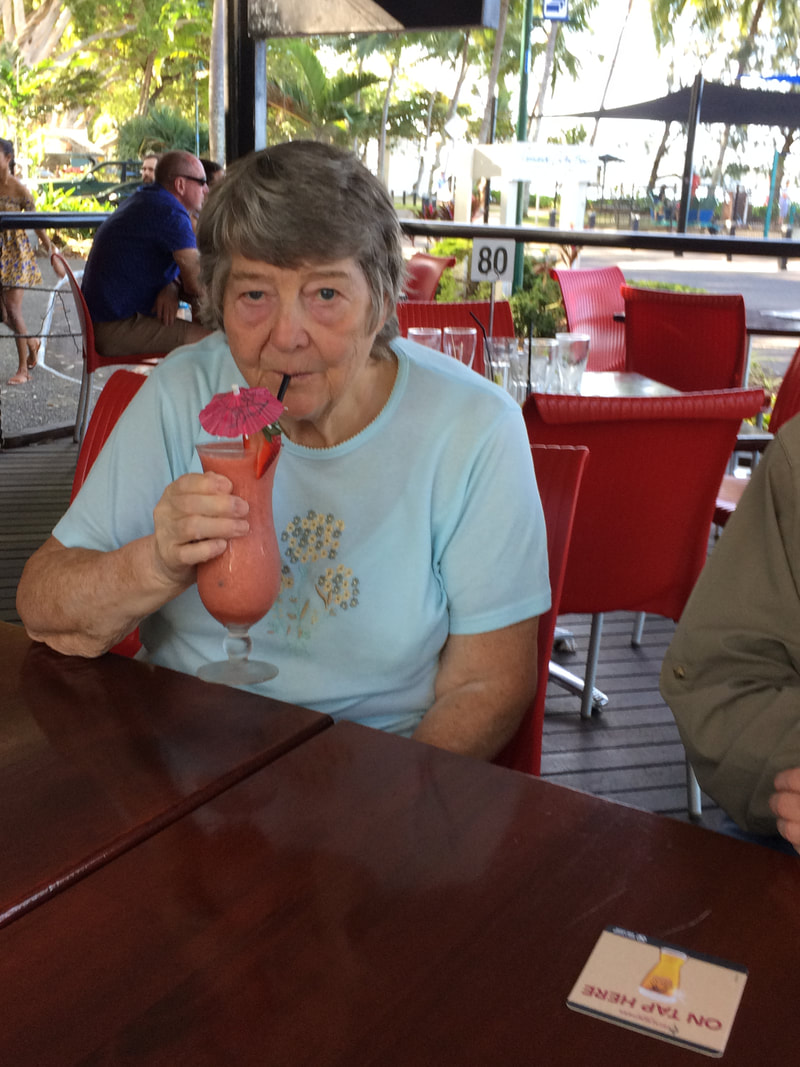
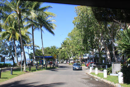
We were met by our guide at Smithfield, the terminus of the Skyrail. She then took us back to beautiful Palm Cove where the blue waters lap the sandy beach which is edged by tall Palm trees that are protected by law. Buildings are built round the trees or the palms are incorporated into the structure of the building!
A truly magnificent day.
Our third day at Pandanus Tourist Park. It was dry overnight and today is a little brighter with a light breeze.
Spent the morning doing the laundry. After lunch set out to find a car wash. It's been two months and 8000 miles of very dusty sandy roads since Nicolle was cleaned! We also needed to do some food shopping and hopefully we might find somewhere where there is internet.
The lady running the campsite has managed to book us onto the Kuranda Skyrail and Scenic Train Tour tomorrow (the man at the tourist office had told us it was full) so we've booked another day on the campsite.
Friday 20th July
Today we joined a small tour group for a trip to the Kuranda Scenic Railway followed by the Skyrail Rainforest Cableway.
We were picked up from the campsite by our friendly and efficient guide/ driver, Hilary at 8.30am. The journey south towards Cairns was a destination in itself. The Captain Cook highway hugs the coast between Port Douglas and Cairns. Sparkling blue sea edged by pristine sandy beaches on one side and thick tropical forests on the other. Dotted along the shoreline were a number of picturesque villages including Palm Cove, an upmarket seaside village where we were to stop for cocktails later in the day. We spotted a crocodile on a muddy river bank and on the outskirts of the suburbs of Cairns there was a field, quite literally covered with wallabies.
Our destination for the day was the small inland village of Kuranda which lies in the middle of the World Heritage Rainforest, 1000ft above Cairns. The village, which has a quirky mix of shops and markets, gained fame in the 1960s when hippies discovered its charm and moved in.
As well as driving to Kuranda you can also visit it by using the Kuranda Scenic Railway or the Skyrail. Our trip included an ascent on the railway and return in the gondola.
The Kuranda Scenic Railway track was originally built in the late 1880s so that the ores from the rich mining belt, including gold, which had developed on the Atherton Highlands could be more easily transported down to the coast. Today, trains leave Cairns for the hour and a half journey along the picturesque track carrying tourists rather than precious metals. There is an onboard commentary describing each section of the track and explaining the difficulties encountered in constructing the railway on the precipitous slopes through the tropical rainforest.
The station at Kuranda was built in 1915 and many of the railway carriages date from the 1930s. Kuranda itself is really just two streets and two market areas. We wandered around the latter then had a "German" lunch, John was very pleased that they served real German beer!
After lunch we headed for the Skyrail Rainforest Cableway. As we glided high above the rainforest canopy, we had far reaching views across to Cairns. At Red Peak Station we had to change to a different cable car so before we did this we followed the short broad walk through the rainforest.
We were met by our guide at Smithfield, the terminus of the Skyrail. She then took us back to beautiful Palm Cove where the blue waters lap the sandy beach which is edged by tall Palm trees that are protected by law. Buildings are built round the trees or the palms are incorporated into the structure of the building!
A truly magnificent day.
|

|
|
|
Saturday 21st July
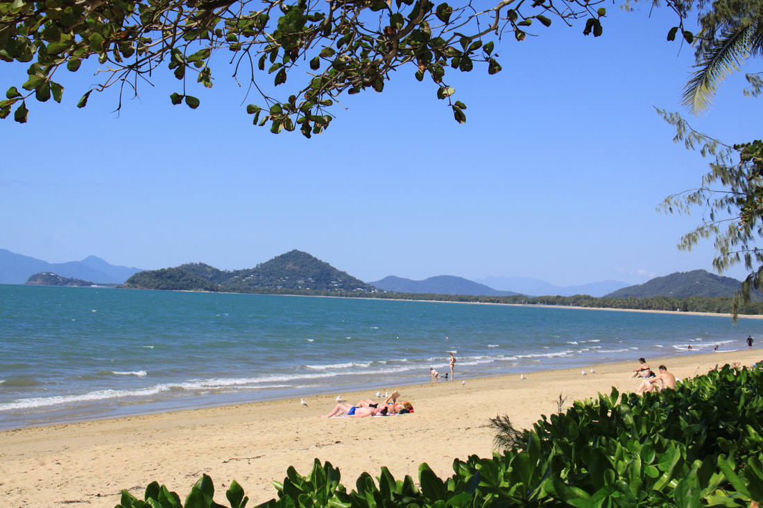
We left Port Douglas this morning and headed south along the Captain Cook Highway towards Cairns. This was the same route which we had gone along yesterday. Today, as we were under our own steam, we had time to stop and admire the scenery from a number of lookout parking areas. It is a beautiful scenic stretch of coastline.
At Palm Cove we walked along the shady path between sandy beach and the line of upmarket hotels and apartments that look out over the sea. People were paddling in the sea despite warnings that saltwater crocodiles and "stingers" were found in this area of sea.
After a visit to MacDonalds to access their free wifi, we headed on to Cairns, then south on the Bruce Highway. The main road is inland here and passes through agricultural land with sugar cane being the main crop.
We stopped for the night at Babenda with its popular overnight rest area.
|
|
|
|
Sunday 22nd July
We awoke to a dull, drizzly day with the clouds down across the Atherton tablelands inland from where we were.
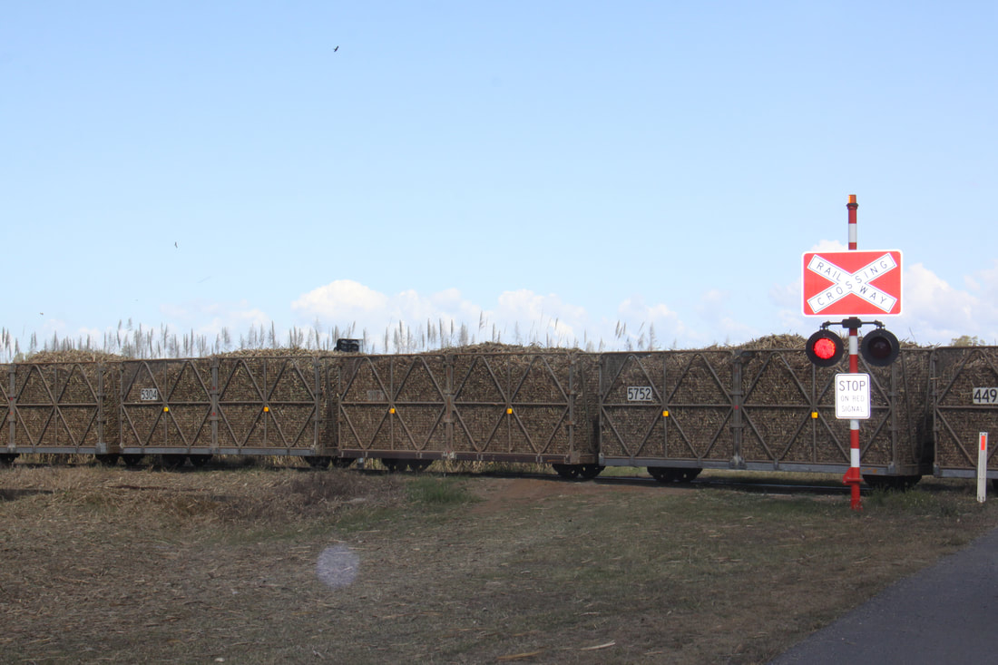
Today turned into a short driving day following the Bruce Highway south. This entire area is sugar cane country so the main road was criss-crossed with the narrow gauge railway lines of the sugar cane trains. Bananas were also grown in this area.
We stopped at Innisfail with its distinctive Art Deco style architecture for food and fuel before heading to Tully with its belching sugar cane processing plant. A few light showers accompanied our drive - Tully has the highest rainfall of anywhere in Australia! Some 20km further south, surrounded by tropical forest, was our overnight stop at Bilyana rest area.
Monday 23rd July
We continued our route south today, still following the Bruce Highway (Route 1), the only coastal route south. The clouds were down on the coastal highlands and we had intermittent showers all morning. We made just one stop at a coastal lookout where the road crossed a spur of high land. Unfortunately the view across to Hinchinbrook Island was poor due to the visibility. By the lookout aerial tracks had been installed so that the long tailed possums could cross the busy highway safely.
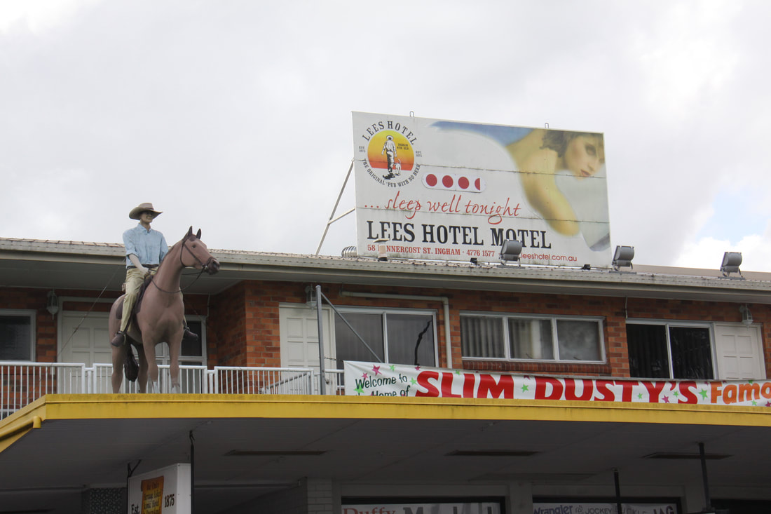
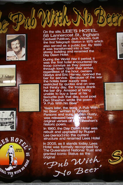
Our main stop today was in the small ton of Ingham in the heart of sugar cane territory. We lost count of the number of times the sugar cane railway crossed the main road. Ingham is well known as the home of Lee's Hotel, formerly known as Day Dawn Hotel or the "Pub With No Beer". During WW2, troops heading north from Townsville drank the pub dry! This event was recorded by local poet Dan Sheahan and the poem formed the basis of the Slim Dusty song.
Tonight we managed to find a spot in the pretty Bushy Parker Memorial Park at Rollingstone. Bushy Parker was a WW2 RAF pilot who, on capture, was sent to Colditz PoW camp. Whilst there he tried to escape three times.
We awoke to a dull, drizzly day with the clouds down across the Atherton tablelands inland from where we were.
Today turned into a short driving day following the Bruce Highway south. This entire area is sugar cane country so the main road was criss-crossed with the narrow gauge railway lines of the sugar cane trains. Bananas were also grown in this area.
We stopped at Innisfail with its distinctive Art Deco style architecture for food and fuel before heading to Tully with its belching sugar cane processing plant. A few light showers accompanied our drive - Tully has the highest rainfall of anywhere in Australia! Some 20km further south, surrounded by tropical forest, was our overnight stop at Bilyana rest area.
Monday 23rd July
We continued our route south today, still following the Bruce Highway (Route 1), the only coastal route south. The clouds were down on the coastal highlands and we had intermittent showers all morning. We made just one stop at a coastal lookout where the road crossed a spur of high land. Unfortunately the view across to Hinchinbrook Island was poor due to the visibility. By the lookout aerial tracks had been installed so that the long tailed possums could cross the busy highway safely.
Our main stop today was in the small ton of Ingham in the heart of sugar cane territory. We lost count of the number of times the sugar cane railway crossed the main road. Ingham is well known as the home of Lee's Hotel, formerly known as Day Dawn Hotel or the "Pub With No Beer". During WW2, troops heading north from Townsville drank the pub dry! This event was recorded by local poet Dan Sheahan and the poem formed the basis of the Slim Dusty song.
Tonight we managed to find a spot in the pretty Bushy Parker Memorial Park at Rollingstone. Bushy Parker was a WW2 RAF pilot who, on capture, was sent to Colditz PoW camp. Whilst there he tried to escape three times.
|
|
Tuesday 24th July
A very short drive today to Saunders Beach, a beautiful over-night seaside spot in a tiny village which has a pub but no shop. Took a walk along the beach and round to the estuary where the rainforest swept down to the water. Spent the rest of the day relaxing under the palm trees and planning our route for the next few days.
Wednesday 25th July
Our overnight halt had definitely filled up by this morning - double and even treble parking! We were fortunate to have been parked where getting out wasn't too much of a problem.
The planned stop for this morning was Townsville, but it was far too busy even in the suburbs that spread for 10 to 15km from the centre. So after shopping for today's meals and accessing wifi from seats outside the Target store, we quickly moved on.
Our journey continued through agricultural land, mainly sugarcane and bananas but still a lot of cattle. We drove through the interesting town of Ayr and crossed the amazing iron framed Burdekin Bridge. Unfortunately there was nowhere to stop to take a photo of this iconic bridge.
At our overnight halt we met a couple who run an enterprise dealing with shipping of vehicles, mainly between Australia and New Zealand.
Thursday 26th July
Onwards south following the Pacific Way (Highway 1). Our first stop was at Bowen, famed for being the setting for the 2008 film "Australia". The waterfront was used as the 1940s Darwin. The town was very spread out - there were a number of historic clapboard buildings and large murals on the sides of some of the stores and a pleasant seaside promenade. Unfortunately the road up to a coastal lookout on Flagstaff Hill was closed.
We had planned on stopping for the night en route to MacKay but the 24 hour rest area was dire - dusty, dirty and full of lorries. We had no choice but to drive on for another hour to The Leap. This was a lovely, if rather noisy spot due to its closeness to the main road. The Leap was the name of the hotel, historic but badly in need of a coat of paint, whose grounds made up the overnight parking area.
Friday 27th July
A very short drive this morning took us to Cape Hillsborough National Park where we booked into the Nature Tourist Park at Casuarina Beach. This is one beautiful beachside camping area and we were fortunate enough to be allocated a pitch overlooking the azure blue sea and golden sands fringed with trees - absolutely picture perfect.
We spent the day relaxing and walking along the beach - the activity would be between dusk and dawn when the wallabies and kangaroos come down to the beach. Unfortunately none put in an appearance this evening although a few had been seen on the campsite.
|
|
Saturday 28th July
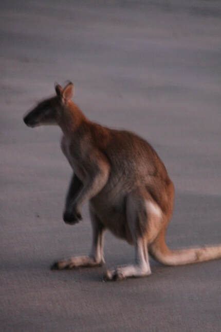
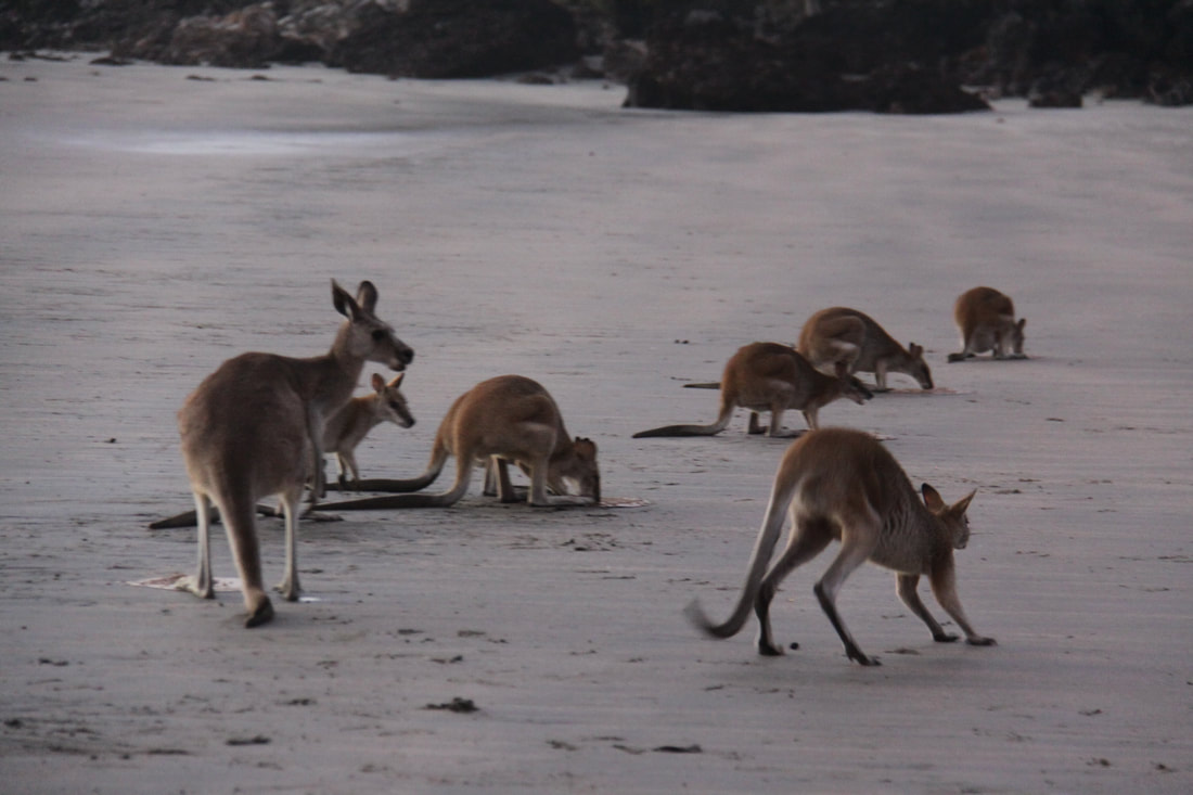
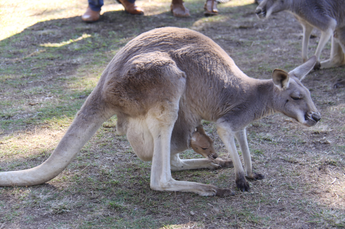
Set an alarm so that we could get up before dawn in order to see the kangaroos and wallabies on the beach. At 6am it was starting to get light and we could see shapes scattered around. By the time the sun rose there were at least a dozen wallabies and two kangaroos feeding on the seaweed. One of the female wallabies had a joey in her pouch. A member of the national park team came down to the beach to feed them and talk to us. We spent a good hour watching and taking photos as the morning grew lighter, before heading back for coffee and breakfast.
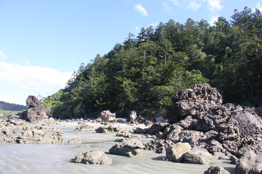
Having enjoyed yesterday and this morning so much we decided to stay another day. It is such an idyllic spot and our camping pitch is so perfect, right on the beach with a wonderful view. We spent the day strolling on the beach - beautiful golden sands with weirdly wonderful volcanic rock formations, encrusted with sea shells and tiny specks of mica - and along the foreshore with palms and mangroves overhanging the beach. In places the roots of trees have been exposed where the tide has washed away the sandy soil and several sun bleached trunks litter the shoreline. In amongst the trees we saw a number of wallabies and kangaroos.
After their feast of seaweed, most of the kangaroos and wallabies headed into the forest but two kangaroos spent most of the day nibbling the grass and dozing in the shade outside the campsite laundry.
The day ended with delicious fish and chips and an icecream from the campsite kitchen.
Set an alarm so that we could get up before dawn in order to see the kangaroos and wallabies on the beach. At 6am it was starting to get light and we could see shapes scattered around. By the time the sun rose there were at least a dozen wallabies and two kangaroos feeding on the seaweed. One of the female wallabies had a joey in her pouch. A member of the national park team came down to the beach to feed them and talk to us. We spent a good hour watching and taking photos as the morning grew lighter, before heading back for coffee and breakfast.
Having enjoyed yesterday and this morning so much we decided to stay another day. It is such an idyllic spot and our camping pitch is so perfect, right on the beach with a wonderful view. We spent the day strolling on the beach - beautiful golden sands with weirdly wonderful volcanic rock formations, encrusted with sea shells and tiny specks of mica - and along the foreshore with palms and mangroves overhanging the beach. In places the roots of trees have been exposed where the tide has washed away the sandy soil and several sun bleached trunks litter the shoreline. In amongst the trees we saw a number of wallabies and kangaroos.
After their feast of seaweed, most of the kangaroos and wallabies headed into the forest but two kangaroos spent most of the day nibbling the grass and dozing in the shade outside the campsite laundry.
The day ended with delicious fish and chips and an icecream from the campsite kitchen.
|
|
Sunday 29th July
Another early call so that we could see the kangaroos and wallabies gathering on the beach again. Two had joeys in their pouches today and our "friends" from the laundry area were there too. These two didn't mind people being close to them but the others were more skittish. There were far more people on the beach today (two coach loads from a cruise ship berthed off MacKay), so there wasn't the silence of yesterday, and the animals soon dispersed.
Today was mostly a driving day with a stop in MacKay for provisions and a brief stop in sleepy Sarina Beach.
Monday 30th July
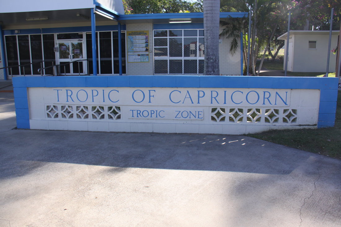
The journey south today took us from tropical Queensland into central temperate Queensland, but before we crossed the Tropic of Capricorn in Rockhampton we headed off the main road and out to the coast.
Yeppoon was a holiday hub and far too busy and cluttered for our liking. However, the coast road from there to Emu Park some 20km further south along the coast proved to be a beautiful scenic drive. Tiny settlements were dotted along the stunning azure blue sea, complete with sandy beaches, rocky headlands and the offshore Keppel Islands.
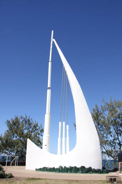
Emu Park was a tranquil little settlement set in a bay between low headlands. The "singing ship" was a quirky monument commemorating Captain James Cook's voyages along this coast in 1770. It is set on a headland so that even a gentle sea breeze produces a fluted sound through its "mast" and "sails".
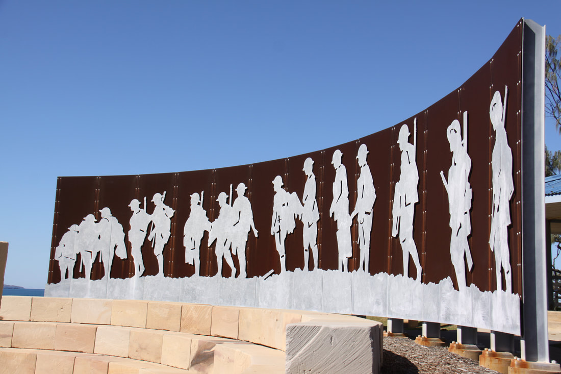
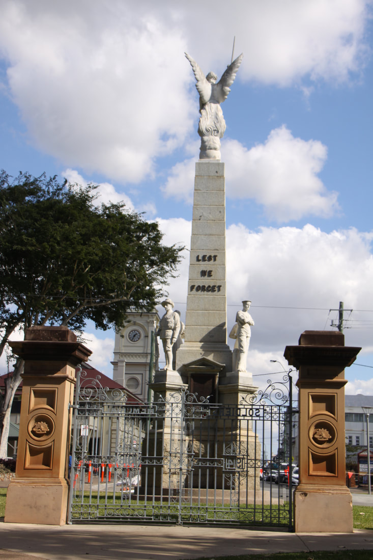
Leading from the "singing ship", a broadwalk with viewing platform forms part of the Centenary of ANZAC memorial walk. Along the path leading to the actual memorial, the names of the major battles during WW1 in which Australians fought whether on land, sea or air, are simply, but very effectively displayed. The main memorial is a cut out relief of soldiers marching into battle - this monument was inspired by a photo of the time. Another memorial suggesting a gatehouse outlined the major battles and the local men and women who served in them. A very poignant memorial walk to ensure that the sacrifices made during WW1 are not forgotten.
Tonight's overnight halt was at Bajool Country Hotel where we also enjoyed a tasty home-cooked dinner.
Another early call so that we could see the kangaroos and wallabies gathering on the beach again. Two had joeys in their pouches today and our "friends" from the laundry area were there too. These two didn't mind people being close to them but the others were more skittish. There were far more people on the beach today (two coach loads from a cruise ship berthed off MacKay), so there wasn't the silence of yesterday, and the animals soon dispersed.
Today was mostly a driving day with a stop in MacKay for provisions and a brief stop in sleepy Sarina Beach.
Monday 30th July
The journey south today took us from tropical Queensland into central temperate Queensland, but before we crossed the Tropic of Capricorn in Rockhampton we headed off the main road and out to the coast.
Yeppoon was a holiday hub and far too busy and cluttered for our liking. However, the coast road from there to Emu Park some 20km further south along the coast proved to be a beautiful scenic drive. Tiny settlements were dotted along the stunning azure blue sea, complete with sandy beaches, rocky headlands and the offshore Keppel Islands.
Emu Park was a tranquil little settlement set in a bay between low headlands. The "singing ship" was a quirky monument commemorating Captain James Cook's voyages along this coast in 1770. It is set on a headland so that even a gentle sea breeze produces a fluted sound through its "mast" and "sails".
Leading from the "singing ship", a broadwalk with viewing platform forms part of the Centenary of ANZAC memorial walk. Along the path leading to the actual memorial, the names of the major battles during WW1 in which Australians fought whether on land, sea or air, are simply, but very effectively displayed. The main memorial is a cut out relief of soldiers marching into battle - this monument was inspired by a photo of the time. Another memorial suggesting a gatehouse outlined the major battles and the local men and women who served in them. A very poignant memorial walk to ensure that the sacrifices made during WW1 are not forgotten.
Tonight's overnight halt was at Bajool Country Hotel where we also enjoyed a tasty home-cooked dinner.
|
|
Tuesday 31st July
Our overnight halt was very close to a busy railway line with several trains every hour including all through the night! Each train consisted of one hundred and two coal wagons hauled by three engines, one at the front, one in the middle and one at the end. A noisy night but we had been well fed so slept soundly.
This morning we headed to the industrial town of Gladstone - the destination of all those coal trucks. It was the nearest sizeable settlement and we needed a food shop, a bank and a Telstra mobile phone shop. The food shopping was done at an Aldi (newly arrived in Australia we think), as we wanted a different choice of meals that we could cook in the motorhome. The bank was no problem, but sorting out John's phone, well that was a sorry tale of woe. Unfortunately the $30 credit we had put on in Fremantle had expired and any new credit we put on now would only last 28 days!
After lunch we turned off the main Pacific Coast Way to visit Agnes Water and 1770. The main road runs inland so to visit the coastal resorts you have to detour off the highway.
Agnes Water is home to the furthest north surfing beach (the sea was like a millpond today so no surfers) while the settlement of 1770 is located along an estuary and headland. It is here that Captain James Cook and his crew from the "Endeavour" came ashore on 20th May 1770, hence the name. It is often called the birthplace of Queensland.
We retraced our steps back to the main highway and our overnight stop was at Granite Creek.
Wednesday 1st August
This morning was spent driving south along the Pacific Way. We then turned off towards the Fraser Coast region, with Hervey Bay as our destination for the day.
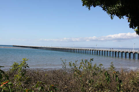
Hervey Bay is situated on a peninsula with a 16km foreshore. The main attraction within the town itself is the 868 metre long wooden jetty known as Urangan Jetty. It is one of the oldest jetties in Australia and was originally built for the regions export of coal and sugar.
Offshore is the protected area known as the Great Sandy Marine Protection Zone, while the UNESCO World Heritage Listed Fraser Island is visible across the Great Sandy Strait.
We overnighted on the Tourist Office car park along with other outfits.
Our overnight halt was very close to a busy railway line with several trains every hour including all through the night! Each train consisted of one hundred and two coal wagons hauled by three engines, one at the front, one in the middle and one at the end. A noisy night but we had been well fed so slept soundly.
This morning we headed to the industrial town of Gladstone - the destination of all those coal trucks. It was the nearest sizeable settlement and we needed a food shop, a bank and a Telstra mobile phone shop. The food shopping was done at an Aldi (newly arrived in Australia we think), as we wanted a different choice of meals that we could cook in the motorhome. The bank was no problem, but sorting out John's phone, well that was a sorry tale of woe. Unfortunately the $30 credit we had put on in Fremantle had expired and any new credit we put on now would only last 28 days!
After lunch we turned off the main Pacific Coast Way to visit Agnes Water and 1770. The main road runs inland so to visit the coastal resorts you have to detour off the highway.
Agnes Water is home to the furthest north surfing beach (the sea was like a millpond today so no surfers) while the settlement of 1770 is located along an estuary and headland. It is here that Captain James Cook and his crew from the "Endeavour" came ashore on 20th May 1770, hence the name. It is often called the birthplace of Queensland.
We retraced our steps back to the main highway and our overnight stop was at Granite Creek.
Wednesday 1st August
This morning was spent driving south along the Pacific Way. We then turned off towards the Fraser Coast region, with Hervey Bay as our destination for the day.
Hervey Bay is situated on a peninsula with a 16km foreshore. The main attraction within the town itself is the 868 metre long wooden jetty known as Urangan Jetty. It is one of the oldest jetties in Australia and was originally built for the regions export of coal and sugar.
Offshore is the protected area known as the Great Sandy Marine Protection Zone, while the UNESCO World Heritage Listed Fraser Island is visible across the Great Sandy Strait.
We overnighted on the Tourist Office car park along with other outfits.
Thursday 2nd August
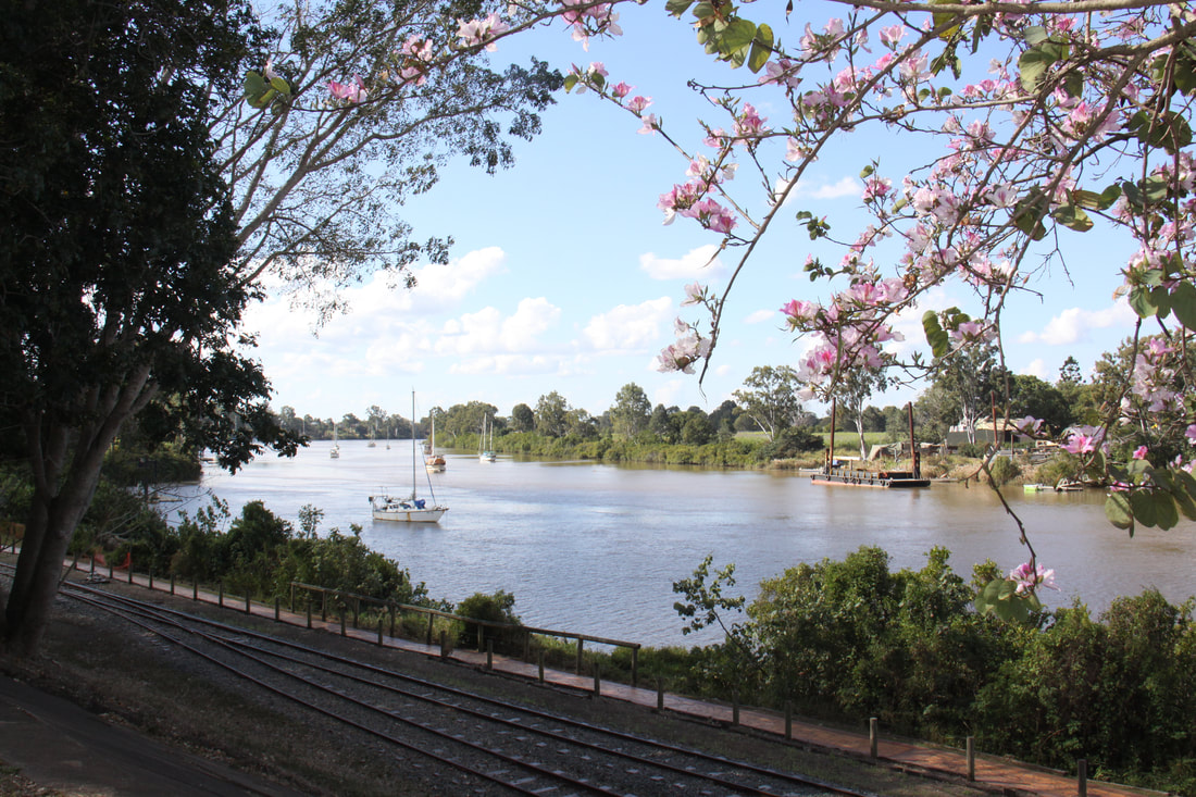
A short drive this morning brought us to historic Maryborough. The town, situated on the Mary River was first settled in 1847 making it one of Australia's oldest cities. These early settlers were "freemen", rather than convicts, who entered the colony between 1859 and 1901. Today the city has retained many buildings dating back to the 19th and early 20th century.
A visit to the Tourist Information Centre with helpful staff soon had us pondering on what to see first - there were a number of different town trails to follow. We decided to use the Discovery Trail as our base and interweave parts of the other trails - Mural, Story, Anzac and Heritage.
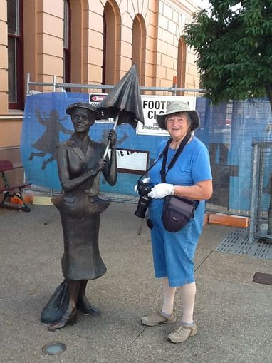
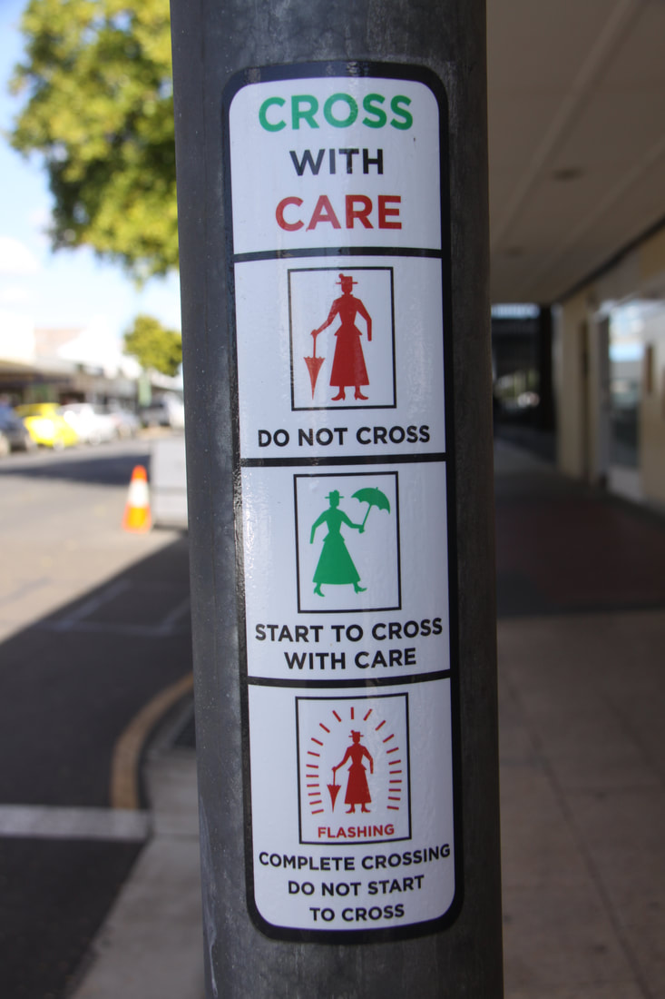
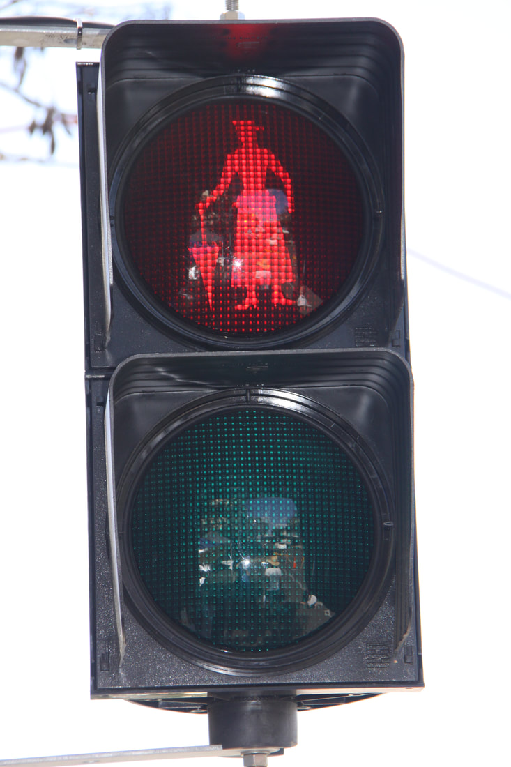
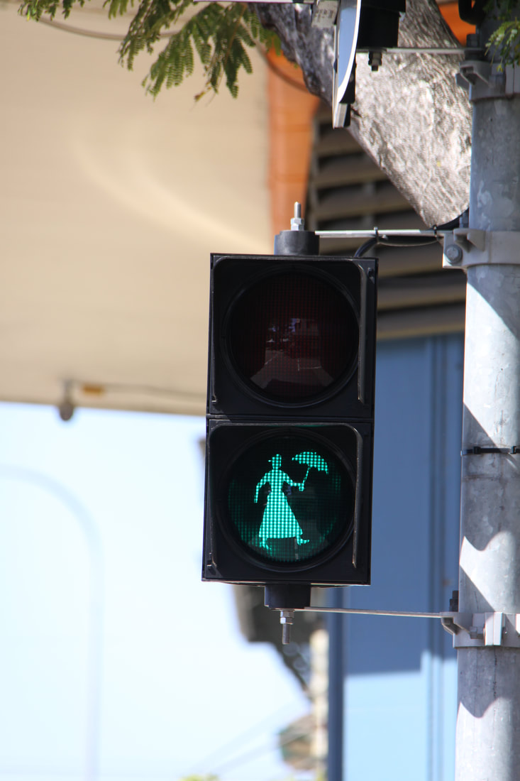
The centre very much has a Mary Poppins feel to it. The author P.L.Travers grew up in Maryborough. A statue of Mary Poppins stands alongside alongside the author's home, the pedestrian lights show Mary Poppins crossing the street, metal columns depict some of P.L.Travers' stories as does a colourful mural.
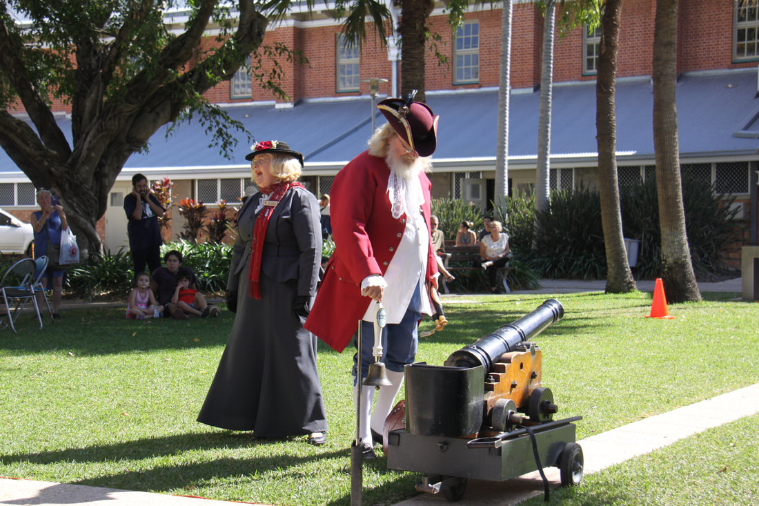
At 1pm, the town crier, with "Mary Poppins" at his side, fired a canon. Tradition has it that, not only did this enable sea captains to set their chronometers, but also reminded the early settlers, who had come from all over the globe, what the time was in Australia!
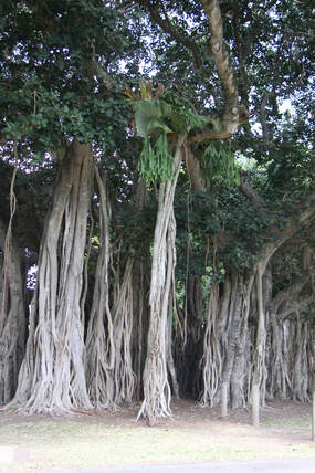
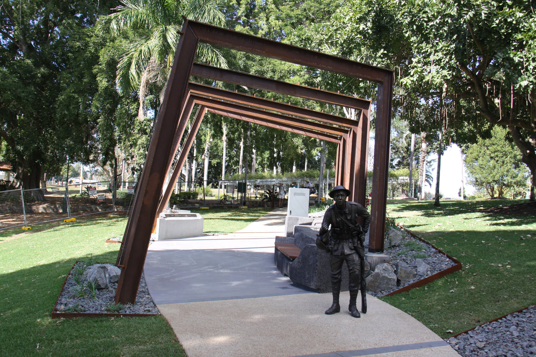
After a tasty bratwurst lunch from a stall on the market, we headed towards Queen's Park admiring all the impressive buildings (although not all were in prime condition). Queen's Park was one of Australia's earliest botanical gardens with some trees dating back to 1864. A magnificent banyan tree was particularly impressive. The city has made the most of the park with its views across the Mary River, its rotunda, cannons, wishing well and outdoor musical instruments just asking to be played while children climbed the banyan tree. But for us it was the newly installed ANZAC memorial and walk that was the most impressive. Every step was poignant and as you strolled along the path, voices told the stories of local men who fought and died, all accompanied by the sound of marching boots. Words describing various aspects of the battles and bronze statuettes all added to the atmosphere.
A walk through the historical streets bordering the park took us past restored architectural gems of buildings - the Court House, Customs House, Bond Store and former New South Wales Bank, now an informative heritage centre where records of early settlers can be accessed by family tree researchers. We found one Joseph Hughes but no link to John's family.
The city has a centrally placed RV car park so this was our stopping place for the night
A short drive this morning brought us to historic Maryborough. The town, situated on the Mary River was first settled in 1847 making it one of Australia's oldest cities. These early settlers were "freemen", rather than convicts, who entered the colony between 1859 and 1901. Today the city has retained many buildings dating back to the 19th and early 20th century.
A visit to the Tourist Information Centre with helpful staff soon had us pondering on what to see first - there were a number of different town trails to follow. We decided to use the Discovery Trail as our base and interweave parts of the other trails - Mural, Story, Anzac and Heritage.
The centre very much has a Mary Poppins feel to it. The author P.L.Travers grew up in Maryborough. A statue of Mary Poppins stands alongside alongside the author's home, the pedestrian lights show Mary Poppins crossing the street, metal columns depict some of P.L.Travers' stories as does a colourful mural.
At 1pm, the town crier, with "Mary Poppins" at his side, fired a canon. Tradition has it that, not only did this enable sea captains to set their chronometers, but also reminded the early settlers, who had come from all over the globe, what the time was in Australia!
After a tasty bratwurst lunch from a stall on the market, we headed towards Queen's Park admiring all the impressive buildings (although not all were in prime condition). Queen's Park was one of Australia's earliest botanical gardens with some trees dating back to 1864. A magnificent banyan tree was particularly impressive. The city has made the most of the park with its views across the Mary River, its rotunda, cannons, wishing well and outdoor musical instruments just asking to be played while children climbed the banyan tree. But for us it was the newly installed ANZAC memorial and walk that was the most impressive. Every step was poignant and as you strolled along the path, voices told the stories of local men who fought and died, all accompanied by the sound of marching boots. Words describing various aspects of the battles and bronze statuettes all added to the atmosphere.
A walk through the historical streets bordering the park took us past restored architectural gems of buildings - the Court House, Customs House, Bond Store and former New South Wales Bank, now an informative heritage centre where records of early settlers can be accessed by family tree researchers. We found one Joseph Hughes but no link to John's family.
The city has a centrally placed RV car park so this was our stopping place for the night
|
|
|
|

|
|
|
Friday 3rd August
Before we left Maryborough we went back into the historic centre so that I could take more photos under different light conditions. I left John at the Tourist Information Centre updating the blog and doing emails. We both enjoyed this place and were sad to leave.
We didn't drive far today as there were no other suitable stops apart from Six Mile Creek at Gympie. At one time it might have been 6 miles from Gympie but the town has spread since then and it was now in the noisy suburbs!
Saturday 4th August
The climate is definitely changing as today we woke up to early morning mist which had burned off by the time we were ready to set off.
The roads too altered and the highway became a motorway. Our first stop for the day was at The Ginger Factory in Yandina where everything ginger based plus other goodies were available for purchase. Unfortunately my favourite ice cream flavour - gingerbread and lime, was not a available!
At this point we headed inland to follow a scenic drive from Mapleton, via Montville to the busy, cluttered little town of Maleny. The road was along a razor edge ridge with wide views across to the coast. Montville was a charming little village but extremely popular with a large number of visitors browsing the boutique style shops along the Main Street.
The nearer we got to Brisbane, the busier it became so it was with some relief that we reached our campsite for the night.
Sunday 5th to Wednesday 8th August
At Kris and Peter's house in Kenmore, a leafy suburb of Brisbane. Kris and I were pen friends when we were Guides and have kept in touch ever since.
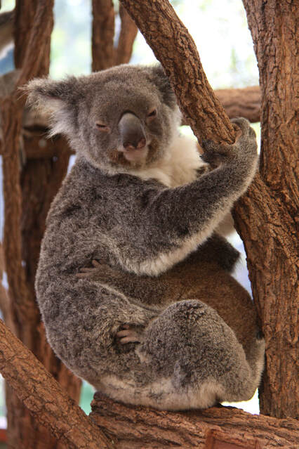
Whilst there we visited the nearby Lone Pine Koala Sanctuary. Apart from Koalas there were many other native animals, birds and reptiles including the rare cassowary on view.
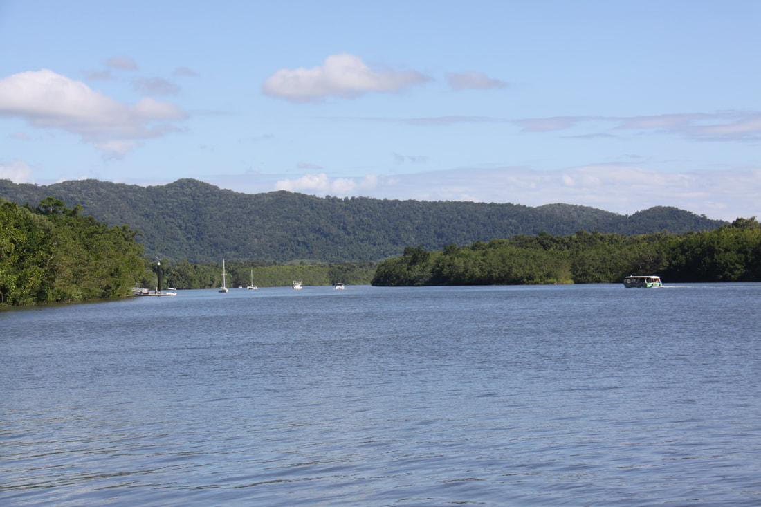
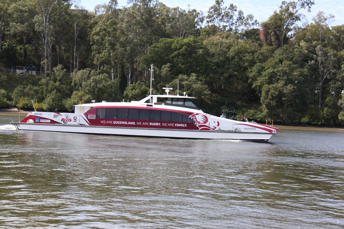
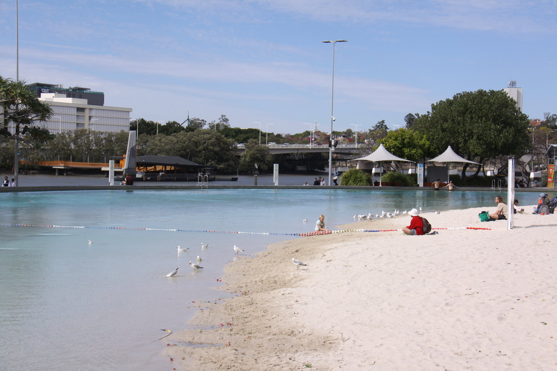
We spent another day on the ferry which cross-crosses the Brisbane River from one side of the city to the other. We stopped for lunch at the South Bank. This area was the site of World Expo 1988. Since then part of the area has been developed as an attractive waterside parkland complete with beach, pool and even a rain forest broadwalk.
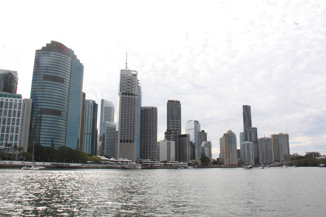
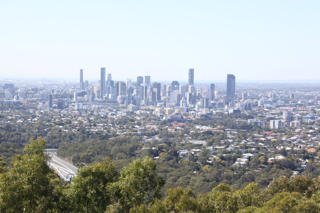
On our final day in Brisbane Kris took us to the lookout on Coot-tha hill where the views across the city and Central Business District, with its many skyscrapers, was very impressive. We then drove into the central area where old runs shoulder with new. The cathedral with its brick clad walls was very imposing.
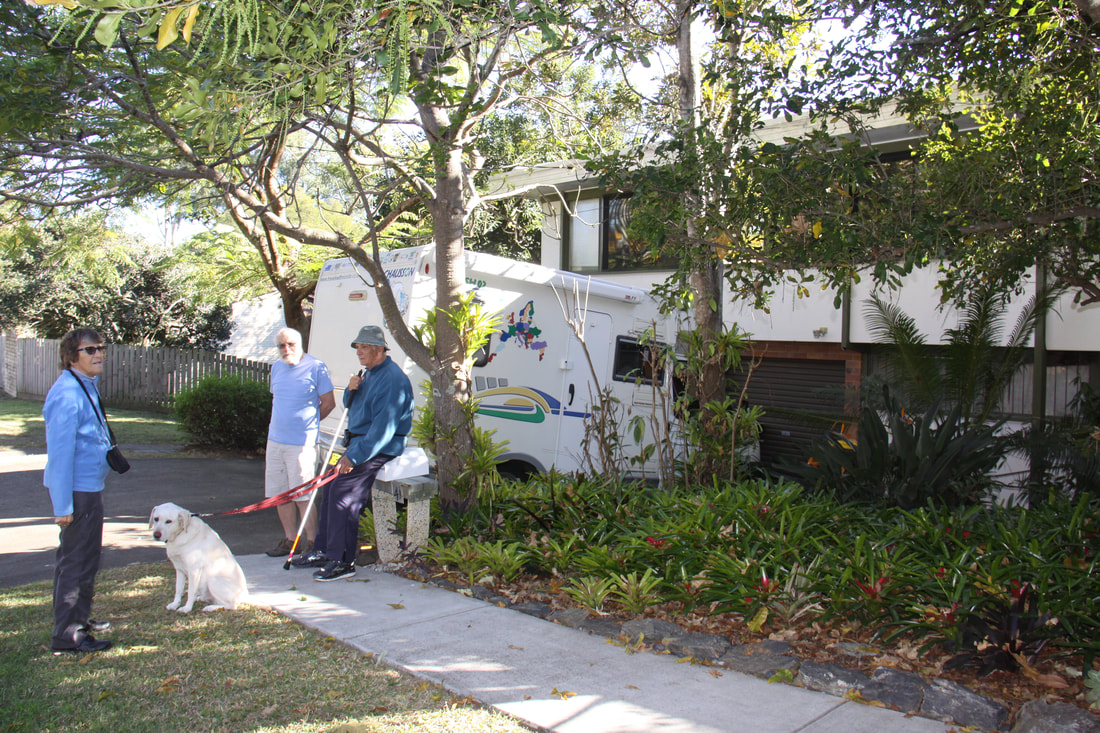
Our visit to Kris, Peter and his guide dog Winnie concluded with a delicious meal at a local Thai restaurant.
Before we left Maryborough we went back into the historic centre so that I could take more photos under different light conditions. I left John at the Tourist Information Centre updating the blog and doing emails. We both enjoyed this place and were sad to leave.
We didn't drive far today as there were no other suitable stops apart from Six Mile Creek at Gympie. At one time it might have been 6 miles from Gympie but the town has spread since then and it was now in the noisy suburbs!
Saturday 4th August
The climate is definitely changing as today we woke up to early morning mist which had burned off by the time we were ready to set off.
The roads too altered and the highway became a motorway. Our first stop for the day was at The Ginger Factory in Yandina where everything ginger based plus other goodies were available for purchase. Unfortunately my favourite ice cream flavour - gingerbread and lime, was not a available!
At this point we headed inland to follow a scenic drive from Mapleton, via Montville to the busy, cluttered little town of Maleny. The road was along a razor edge ridge with wide views across to the coast. Montville was a charming little village but extremely popular with a large number of visitors browsing the boutique style shops along the Main Street.
The nearer we got to Brisbane, the busier it became so it was with some relief that we reached our campsite for the night.
Sunday 5th to Wednesday 8th August
At Kris and Peter's house in Kenmore, a leafy suburb of Brisbane. Kris and I were pen friends when we were Guides and have kept in touch ever since.
Whilst there we visited the nearby Lone Pine Koala Sanctuary. Apart from Koalas there were many other native animals, birds and reptiles including the rare cassowary on view.
We spent another day on the ferry which cross-crosses the Brisbane River from one side of the city to the other. We stopped for lunch at the South Bank. This area was the site of World Expo 1988. Since then part of the area has been developed as an attractive waterside parkland complete with beach, pool and even a rain forest broadwalk.
On our final day in Brisbane Kris took us to the lookout on Coot-tha hill where the views across the city and Central Business District, with its many skyscrapers, was very impressive. We then drove into the central area where old runs shoulder with new. The cathedral with its brick clad walls was very imposing.
Our visit to Kris, Peter and his guide dog Winnie concluded with a delicious meal at a local Thai restaurant.
|

|
|
|
|
|
|
Thursday 9th August
We left Kris and Peter's today after a very pleasant time with them. Kris had been an excellent guide while we were there.
After stocking up with fresh produce we headed west from the city to Toowoomba which is situated on the top of a steep escarpment overlooking the Darling Downs, an area of prime agricultural land between the Great Dividing Range and Brisbane.
Our stop for the night was some 5 miles south of Toowoomba.
Friday 10th August
Today we drove south along the scenic New England Highway. It passes through prime agricultural countryside but due to the ongoing drought everywhere was bleached dry.
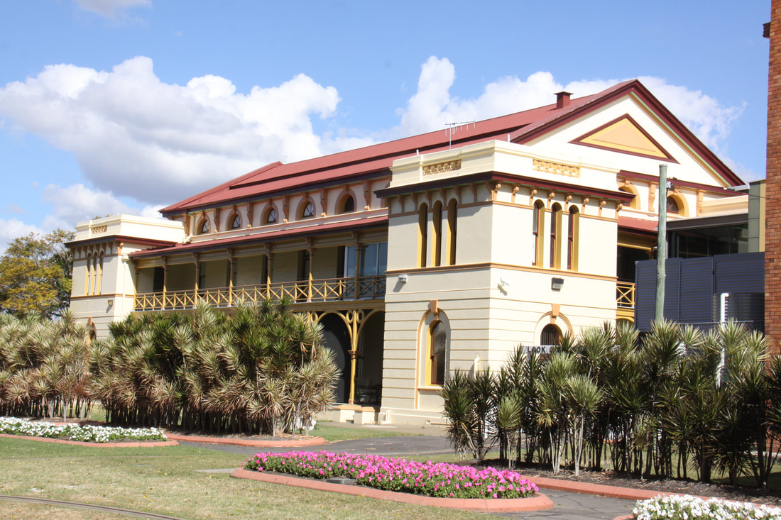
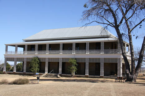
We made a very interesting stop at Glengallan Homestead, an imposing stone built house dating from 1860. It was built for John Deuchar who came from Aberdeen in Scotland to Australia. The success of the Deuchar family was one of boom then bust due to drought, the depression and mounting debt. So three years after the house was built, it had to be sold. Other wealthy owners followed until the 1940s when the contents of the house were sold and the house fell into disrepair. Today it has been restored and is like a time-warp.
Our journey south then took us through a fruit growing area which included vineyards. We stopped for the night at Wallangarra.
We left Kris and Peter's today after a very pleasant time with them. Kris had been an excellent guide while we were there.
After stocking up with fresh produce we headed west from the city to Toowoomba which is situated on the top of a steep escarpment overlooking the Darling Downs, an area of prime agricultural land between the Great Dividing Range and Brisbane.
Our stop for the night was some 5 miles south of Toowoomba.
Friday 10th August
Today we drove south along the scenic New England Highway. It passes through prime agricultural countryside but due to the ongoing drought everywhere was bleached dry.
We made a very interesting stop at Glengallan Homestead, an imposing stone built house dating from 1860. It was built for John Deuchar who came from Aberdeen in Scotland to Australia. The success of the Deuchar family was one of boom then bust due to drought, the depression and mounting debt. So three years after the house was built, it had to be sold. Other wealthy owners followed until the 1940s when the contents of the house were sold and the house fell into disrepair. Today it has been restored and is like a time-warp.
Our journey south then took us through a fruit growing area which included vineyards. We stopped for the night at Wallangarra.